Volume 2: Sustainability Appraisal of the Maidstone Gypsy, Traveller and Travelling Showpeople Development Plan Document 2023–2040
C.1 Introduction
C.1.1 Overview
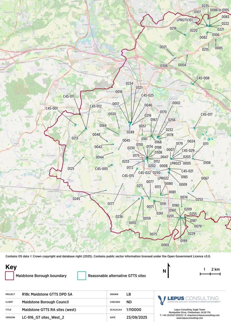
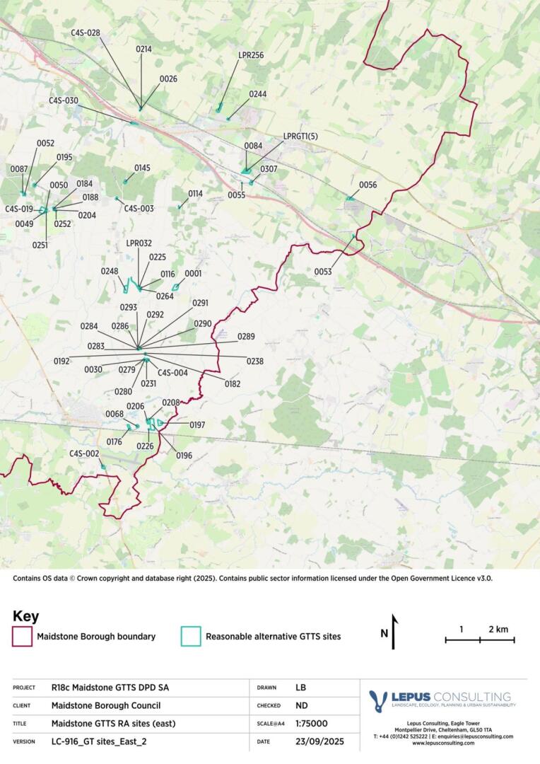
C.1.1.1 A total of 158 reasonable alternative sites have been identified by Maidstone Borough Council (MBC) during the preparation of the Gypsy, Traveller and Travelling Showpeople (GTTS) Development Plan Document (DPD).
C.1.1.2 The location of the 158 reasonable alternative sites is shown in Figure C.1.1 and C.1.2, and their specifications as provided by MBC are summarised in Table C.1.1.
C.1.1.3 Each of the sites appraised within this report have been assessed for likely impacts on each of the 13 SA Objectives, as outlined in the SA Framework (see Appendix A). Likely sustainability impacts have been set out in Tables C.2.1 to C.14.1 against each receptor within each SA Objective chapter, in accordance with the site assessment methodology set out in Appendix B, as well as the methodology information set out in Chapter 2 of the main Regulation 18c SA Report (see Volume 1).
C.1.1.4 The receptor-only impacts, based on the red line boundary and site proposal information provided by MBC, help to identify the potential impacts on site if there were no policy or mitigation. The potential mitigating influence of the MBC GTTS DPD policies (alongside other adopted plan policies) is considered within Appendix E.
C.1.1.5 It should be noted that whilst every effort has been made to predict effects accurately, the sustainability impacts have been assessed at a high level and are reliant upon the current understanding of the baseline. These assessments have been based on information provided by the Council as well as expert judgement.
Table C.1.1: Reasonable alternative GTTS sites in Maidstone
|
Site ref. |
Site name |
Parish |
Area (ha) |
Existing numberofpitches |
Potential net gain in pitches |
|
0001 |
Petsfield, Eastwood Road |
Boughton Malherbe |
2.07 |
2 |
5 |
|
0002 |
Two Acres, Park Lane |
Boughton Monchelsea |
0.71 |
1 |
5 |
|
0004 |
Fairview, Osbourne Drive |
Thurnham |
0.71 |
6 |
4 |
|
0005 |
Little Acre, Chart Hill Road |
Chart Sutton |
0.41 |
2 |
2 |
|
0007 |
Plot 5 Peacock Farm, Chart Hill Road |
Chart Sutton |
0.27 |
1 |
7 |
|
0008 |
1 Chart View, Chart Hill Road |
Chart Sutton |
0.31 |
1 |
2 |
|
0009 |
Chart Hill Paddock, Chart Hill Road |
Chart Sutton |
1.71 |
5 |
1 |
|
0010 |
Twin Oaks, Howland Road |
Marden |
1.25 |
3 |
3 |
|
0017 |
Primrose Paddock, Stockett Lane |
Coxheath |
0.85 |
2 |
2 |
|
0018 |
Blossom Lodge, Land of Stockett Lane |
Coxheath |
1.49 |
4 |
4 |
|
0020 |
Yelton, Heath Road |
Coxheath |
0.13 |
2 |
2 |
|
0021 |
Detling Lime Works, Hermitage Lane |
Detling |
0.10 |
1 |
2 |
|
0024 |
Land Adj Horseshoe Paddock, Lucks Lane |
Chart Sutton |
0.04 |
1 |
2 |
|
0026 |
Oakland Place, Greenway Forstal |
Harrietsham |
0.08 |
2 |
2 |
|
0030 |
1 Greengates |
Headcorn |
0.13 |
1 |
1 |
|
0042 |
Mulberry Farm, East Street |
Hunton |
0.64 |
5 |
3 |
|
0044 |
Little Clock House, George Street |
Hunton |
0.11 |
2 |
2 |
|
0045 |
Land Rear of Brickyard Cottages, Redwall Lane |
Hunton |
0.42 |
2 |
2 |
|
0046 |
Forstal Farm, Forstal Lane |
Coxheath |
0.08 |
1 |
4 |
|
0047 |
Greenfields, Stilebridge Lane |
Linton |
0.42 |
2 |
2 |
|
0048 |
The Chances, Lughorse Lane |
Hunton |
0.40 |
4 |
1 |
|
0049 |
Bridgefield, Chartway Street |
Broomfield and Kings |
0.27 |
4 |
4 |
|
0050 |
The Glen, Chartway Street |
Broomfield and Kings |
0.50 |
6 |
5 |
|
0052 |
Bramblewood, Pitt Road |
Langley |
0.50 |
7 |
14 |
|
0053 |
Part Norham Farm, Lenham Heath Road |
Lenham |
0.27 |
6 |
4 |
|
0055 |
The Old Woodyard, Headcorn Road |
Lenham |
0.07 |
1 |
1 |
|
0056 |
Wheatgratten, Lenham Forstal Road |
Lenham |
1.70 |
7 |
3 |
|
0057 |
The Kays, Heath Road |
Linton |
0.27 |
1 |
2 |
|
0059 |
Plum Tree Farm, Park Road |
Marden |
0.17 |
2 |
4 |
|
0067 |
Little Boarden, Boarden Lane |
Headcorn |
0.25 |
3 |
2 |
|
0068 |
Abbeywood Stud Farm, Love Lane |
Headcorn |
0.57 |
1 |
2 |
|
0069 |
Little Oak Farm, Frittenden Road |
Staplehurst |
0.61 |
3 |
5 |
|
0071 |
Stable Paddocks, Marden Road |
Staplehurst |
0.60 |
4 |
4 |
|
0074 |
Oak Tree Farm, Cradducks Lane |
Staplehurst |
0.40 |
7 |
7 |
|
0075 |
Woodside Place, Goudhurst Road |
Staplehurst |
0.20 |
5 |
2 |
|
0077 |
Little Acre, Marden Road |
Staplehurst |
0.11 |
2 |
1 |
|
0079 |
1 Perfect Place |
Staplehurst |
0.29 |
4 |
2 |
|
0080 |
Blue Bell Farm, George Street |
Staplehurst |
0.31 |
2 |
1 |
|
0081 |
The Paddocks, George Street |
Staplehurst |
0.40 |
2 |
9 |
|
0082 |
Seaview Farm, South Street Road |
Stockbury |
0.75 |
8 |
4 |
|
0083 |
Land At Cherry Tree Farm, West Wood Road |
Stockbury |
0.53 |
2 |
2 |
|
0084 |
Kilnwood Farm, Old Ham Lane |
Lenham |
2.62 |
2 |
1 |
|
0085 |
Jackswood |
Stockbury |
0.63 |
1 |
2 |
|
0087 |
Bramblewood Stables, Pitt Road |
Langley |
0.25 |
5 |
12 |
|
0088 to 0105 |
Plum Tree Lane |
Stockbury |
2.36 |
11 |
21 |
|
0106 |
Flips Hole, South Street Road |
Stockbury |
0.59 |
2 |
3 |
|
0107 |
The Ash, Yelsted Road |
Stockbury |
1.65 |
2 |
4 |
|
0108 |
The Stables Brookfield, Forsham Lane |
Sutton Valence |
0.53 |
6 |
2 |
|
0111 |
Somersby Stables, Headcorn Road |
Sutton Valence |
0.13 |
3 |
3 |
|
0112 |
Whitehouse Farm, Stilebridge Lane |
Linton |
0.65 |
4 |
4 |
|
0113 |
Land off Clapper Lane/Oak Tree Stud |
Staplehurst |
0.16 |
1 |
1 |
|
0114 |
The Vine, Green Hill Lane |
Ulcombe |
0.22 |
5 |
2 |
|
0116 |
Hawthorn Farm, Pye Corner |
Ulcombe |
0.51 |
2 |
1 |
|
0125 |
Emmett Hill Nursery, Emmet Hill Lane |
Yalding |
0.73 |
2 |
2 |
|
0145 |
Water Lane Caravan Site, Water Lane |
Ulcombe |
0.69 |
14 |
7 |
|
0160 and 0275 |
The Stables (1 and 2), Frittenden Road |
Staplehurst |
0.18 |
2 |
3 |
|
0161 |
Fairway, Church Hill |
Broughton Monchelsea |
0.49 |
2 |
4 |
|
0167 |
Cobnut Tree Place (Plot 1), Church Hill |
Boughton Monchelsea |
0.37 |
1 |
1 |
|
0168 |
Greenacre (Plot 5), Church Hill |
Boughton Monchelsea |
0.34 |
1 |
2 |
|
0169 |
Land Adjacent Amsbury Cottage, Amsbury Road |
Coxheath |
0.12 |
1 |
1 |
|
0170 |
Four Oakes (Plot 2), Church Hill |
Boughton Monchelsea |
0.48 |
3 |
5 |
|
0172 |
Five Oak Stables, Stilebridge Lane |
Linton |
0.20 |
1 |
1 |
|
0174 |
Stilebridge Paddock/The Willows |
Linton |
0.49 |
2 |
2 |
|
0175 |
Stilebridge Stableyard, Stilebridge Lane |
Linton |
0.17 |
1 |
1 |
|
0176 |
Love Lane Stables |
Headcorn |
0.87 |
1 |
3 |
|
0177 |
1 Oak Lodge, Tilden Lane, Marden |
Marden |
0.07 |
2 |
0 |
|
0178 |
The Orchards |
Boughton Monchelsea |
0.29 |
10 |
1 |
|
0179 |
Little Appleby, Lucks Lane |
Chart Sutton |
0.15 |
6 |
7 |
|
0182 |
Plot 3 The Meadows (Vale End) |
Headcorn |
0.09 |
2 |
3 |
|
0184 |
Orchard Place |
Broomfield and Kings |
0.29 |
2 |
2 |
|
0185 |
Old Oak Paddocks, Chart Hill Road |
Chart Sutton |
0.55 |
1 |
2 |
|
0187 |
Park Wood Stables, Parkwood Lane |
Staplehurst |
0.36 |
2 |
3 |
|
0188 |
Orchard Farm Nursery, Plot 1, Chartway Street |
Broomfield and Kings |
0.13 |
3 |
3 |
|
0190 |
The Oakes, Frittenden Road |
Staplehurst |
0.14 |
1 |
1 |
|
0191 |
Meadow View, Marden Road |
Staplehurst |
0.62 |
3 |
3 |
|
0192 |
4 The Meadows, Lenham Road |
Headcorn |
0.04 |
1 |
2 |
|
0195 |
Oaklands, Gravelly Bottom Road |
Broomfield and Kings |
0.55 |
1 |
1 |
|
0196 |
The Pottery |
Headcorn |
3.70 |
3 |
3 |
|
0197 |
Ten Acre Farm |
Headcorn |
1.67 |
1 |
1 |
|
0198 |
Land Adjacent to The Paddock- The Orchard/ The Willows |
Linton |
0.21 |
3 |
3 |
|
0199 |
Delilah Lodge Frittenden Road |
Staplehurst |
0.53 |
3 |
2 |
|
0201 |
Blossom |
Staplehurst |
0.10 |
1 |
1 |
|
0202 |
Land South East of Stilebridge Lane (The Barn) |
Linton |
1.35 |
2 |
2 |
|
0203 |
Peas Place Green Lane |
Chart Sutton |
0.20 |
1 |
2 |
|
0204 |
Orchard Farm, Nursery (Plot 1), Chartway Street |
Broomfield and Kings |
0.23 |
1 |
1 |
|
0206 |
Faithfields Land Adjacent The Potters |
Headcorn |
0.60 |
1 |
2 |
|
0208 |
Smiths View Adjacent The Potters |
Headcorn |
0.81 |
1 |
1 |
|
0209 |
Plot 2 The Oakes, Frittenden Road |
Staplehurst |
0.10 |
1 |
2 |
|
0211 |
Udene Barn Stud, Marden Road |
Staplehurst |
0.70 |
4 |
2 |
|
0213 |
Highlands Farm, Yalding Hill |
Yalding |
0.56 |
2 |
1 |
|
0214 |
Hawthorne Place |
Harrietsham |
0.08 |
2 |
1 |
|
0215 |
Land At Stockbury Valley |
Thurnham |
0.06 |
4 |
2 |
|
0216 |
Rosewood Farm, Scragged Oak Road |
Detling |
1.60 |
2 |
5 |
|
0219 |
Land Adj Forstal Farm, Forstal Lane |
Coxheath |
0.05 |
2 |
1 |
|
0220 |
Plot A, Plum Tree Lane |
Stockbury |
0.08 |
1 |
2 |
|
0221 |
Plot B, Plum Tree Lane |
Stockbury |
0.10 |
1 |
2 |
|
0222 |
Plot C, Plum Tree Lane |
Stockbury |
0.13 |
3 |
6 |
|
0225 |
Caravan 2, Hawthorn Farm |
Headcorn and Sutton Valence |
0.20 |
2 |
2 |
|
0226 |
The Ewes Smarden Road |
Headcorn |
0.09 |
1 |
3 |
|
0229 |
The Acorns Frittenden Road |
Staplehurst |
0.63 |
3 |
2 |
|
0230 |
Rose Garden |
Linton |
0.09 |
1 |
1 |
|
0231 |
Cobtree Meadows, Land adjoining Greengates |
Headcorn |
0.38 |
2 |
3 |
|
0232 |
Dunroamin, Park Lane |
Boughton Monchelsea |
0.93 |
4 |
1 |
|
0233 |
Land West of The Barn Stilebridge Lane |
Linton |
0.18 |
1 |
0 |
|
0234 |
Land East of Blossom Lodge |
Coxheath |
0.65 |
10 |
8 |
|
0235 |
Yelsted Farm, Yelsted Road |
Stockbury |
0.88 |
1 |
1 |
|
0236 |
The Orchard, Copper Lane |
Marden |
1.14 |
5 |
3 |
|
0238 |
3 and 4 Ash Gardens/ Ash Gardens/ Plot 2 The Meadows |
Lenham Road |
0.09 |
1 |
1 |
|
0244 |
Chestfields, Marley Road |
Harrietsham |
0.28 |
2 |
6 |
|
0245 |
Longend Meadow |
Collier Street |
0.36 |
2 |
2 |
|
0248 |
Land Rear of Little Neverend Farm |
Ulcombe |
1.91 |
8 |
5 |
|
0249 |
Broken Tree Forstal Lane |
Coxheath |
0.17 |
1 |
4 |
|
0250 |
2 Chart View, Chart Hill Road |
Chart Sutton |
0.17 |
1 |
5 |
|
0251 |
Land Adjoining The Glen |
Broomfield and Kings |
0.26 |
2 |
2 |
|
0252 |
Orchard Farm Nursery, Chartway Street |
Broomfield and Kings |
0.13 |
1 |
1 |
|
0253 |
Hawkenbury Acres Hawkenbury Road |
Headcorn |
0.23 |
1 |
1 |
|
0255 |
Three Sons, Parkwood Lane |
Staplehurst |
0.28 |
2 |
4 |
|
0256 |
Robins Rest |
Boughton Monchelsea |
1.37 |
1 |
2 |
|
0261 |
Oak View |
Staplehurst |
0.47 |
1 |
0 |
|
0264 |
Land Adjacent to The Hawthorns |
Ulcombe |
0.38 |
1 |
1 |
|
0279 |
2 Greengates |
Headcorn |
0.07 |
1 |
1 |
|
0280 |
1 Long Lane |
Headcorn |
0.03 |
1 |
1 |
|
0283 |
Land Rear of The Meadows, Pitch 2 |
Headcorn |
0.10 |
1 |
3 |
|
0284 |
3 Land Rear of The Meadows |
Headcorn |
0.16 |
2 |
3 |
|
0286 |
4b Land Rear of The Meadows |
Headcorn |
0.07 |
1 |
2 |
|
0289 |
Land Rear of the Meadows, Oakview |
Headcorn |
0.14 |
1 |
3 |
|
0290 |
7 Land Rear of The Meadows |
Headcorn |
0.07 |
1 |
1 |
|
0291 |
8a Land Rear of The Meadows |
Headcorn |
0.07 |
1 |
1 |
|
0292 |
8b Land Rear of The Meadows |
Headcorn |
0.07 |
1 |
1 |
|
0293 |
New Haven - 9a Land Rear of The Meadows |
Headcorn |
0.07 |
1 |
1 |
|
0306 |
Lynch Bank Farm Barn |
Detling |
0.16 |
1 |
1 |
|
0307 |
Warren Lands, Headcorn Lane |
Lenham |
0.79 |
1 |
7 |
|
0308 |
Violets View |
Linton |
0.05 |
1 |
1 |
|
0310 |
Rose Croft |
Linton |
0.04 |
1 |
1 |
|
0321 |
Land rear of Blossom Lodge |
Coxheath |
0.73 |
10 |
10 |
|
C4S-001 |
Land at Kenward Road/The Cherry Orchard |
Yalding |
2.17 |
0 |
TBC |
|
C4S-002 |
Land adjacent to Shenley Corner |
Headcorn |
0.81 |
0 |
TBC |
|
C4S-003 |
Wood View Farm |
Ulcombe |
0.30 |
0 |
6 |
|
C4S-004 |
Acres Place |
Headcorn |
0.26 |
0 |
6 |
|
C4S-005 |
Dairy Lane |
Marden |
1.84 |
0 |
3 |
|
C4S-008 |
The Lodge |
Thurnham |
1.37 |
0 |
TBC |
|
C4S-011 |
Land Parcel (East) Highlands Farm |
Yalding |
0.45 |
0 |
8 |
|
C4S-012 |
Land Parcel (East) Highlands Farm |
Yalding |
0.58 |
0 |
16 |
|
C4S-015 |
Land at Oakhurst |
Marden |
1.34 |
0 |
15 |
|
C4S-017 |
The Brishings |
Langley |
1.96 |
0 |
20 |
|
C4S-019 |
The Meadow |
Broomfield and Kingswood |
2.35 |
0 |
TBC |
|
C4S-021 |
Chart View (r/o 1 Chart View) |
Chart Sutton |
0.49 |
0 |
20 |
|
C4S-022 |
Five Oaks Stables |
Linton |
0.92 |
0 |
20 |
|
C4S-025 |
Land at Forstal Farm |
Coxheath |
1.28 |
0 |
35 |
|
C4S-028 |
Oakland Place |
Harrietsham |
0.27 |
0 |
12 |
|
C4S-029 |
Peacock Farm |
Chart Sutton |
1.04 |
0 |
15 |
|
C4S-030 |
River Wood |
Harrietsham |
0.58 |
0 |
15 |
|
LPR022 |
Land Rear of Chart View Chart Hill Road - SITE A |
Chart Sutton |
0.17 |
0 |
2 |
|
LPR023 |
Land Rear of Chart View Chart Hill Road - SITE B |
Chart Sutton |
0.19 |
0 |
2 |
|
LPR032 |
Hawthorn Farm Site |
Ulcombe |
0.12 |
0 |
3 |
|
LPR256 |
Stede Row |
Harrietsham |
1.67 |
0 |
TBC |
|
LPRGT1(5) |
Kilnwood Farm, Old Ham Lane, Lenham |
Lenham |
0.42 |
2 |
2 |
|
LPRGT1(10) |
The Ash, Yelsted Road, Stockbury |
Stockbury |
0.59 |
4 |
1 |
C.2 SA Objective 1: Housing
C.2.1 Housing provision
C.2.1.1 The majority of identified reasonable alternative GTTS sites contain existing pitches or plots and as such, the identified need is likely to be contributed to through intensification or expansion. Based on the information provided by the Council, derived from the Pitch Deliverability Assessment1 and liaison with landowners, the number of existing pitches on each site and the anticipated net gain in pitches is set out in Table C.1.1 above, with the total pitch capacity of each site derived from the sum of existing and potential pitches.
C.2.1.2 Table C.2.1 below details the impact each site is anticipated to have on housing. The proposed development at 134 sites have potential for a minor positive impact on housing where it is likely they will provide a capacity of between one and nine pitches. Some 19 sites are expected to have a capacity of 10 pitches or more; there is potential for a major positive impact on housing for these sites.
C.2.1.3 It should be noted that MBC will be carrying out a detailed capacity assessment at each site to understand the deliverability and feasibility of pitches at each site, in accordance with other relevant policy requirements. As such, the capacity figures may be subject to change. At the time of writing, the capacity of Sites C4S-001, C4S-002, C4S-008, C4S- 019 and LPR256 is unknown; the impact of these sites on housing provision is therefore recorded as uncertain.
Table C.2.1: Sites impact matrix for SA Objective 1 – Housing
|
|
C.3 SA Objective 2: Transport and Accessibility
C.3.1.1 Table C.3.1 below sets out a summary of the identified impacts for each receptor in relation to SA Objective 2 (Transport and Accessibility).
C.3.2 Bus stops
C.3.2.1 There are several key bus routes which run within the borough, primarily leading into the town of Maidstone where the most regular bus services are found, with more infrequent services provided throughout the rural settlements.
C.3.2.2 A total of 127 of the GTTS sites are located more than 400m from a bus stop with a frequent service, as the sites are predominantly located in rural parts of the borough. As such, a minor negative impact has been identified for these sites where new residents may be less likely to choose to travel via bus.
C.3.2.3 A total of 16 sites are located within 400m of a bus stop with infrequent services (0002, 0020, 0044, 0053, 0055, 0161, 0167, 0168, 0170, 0184, 0188, 0204, 0252, 0307, C4S-003 and C4S-005). As these sites are already located on a bus route which allows for potential for increased services, a negligible impact is identified for these sites on access to bus services.
C.3.2.4 There are 15 sites where the majority of the site area is located within the identified 400m sustainable target distance of a bus stop providing a frequent service (0001, 0021, 0026, 0048, 0057, 0108, 0111 0125, 0214, 0306, C4S-002, C4S-017, C4S-025, C4S-028 and C4S-030). These sites will therefore be expected to provide residents with sustainable access via bus and as such a major positive impact has been identified.
C.3.3 Railway stations
C.3.3.1 There are 13 railway stations across Maidstone, the majority of which are located in and around Maidstone town, including Maidstone East Station and Maidstone West Station, among others. Several stations are located to the north and east of the borough, such as Hollingbourne and Lenham Stations, as well as several to the south of the borough including Staplehurst and Marden Stations. However, this does leave the central portion of the borough, as well as a large area of the Kent Downs National Landscape within Maidstone Borough, largely disconnected from the rail network.
C.3.3.2 A total of 124 GTTS sites are located beyond the sustainable 2km stretch distance from a national network railway station which is likely to result in a minor negative impact with regard to sustainable access to railway stations for these sites.
C.3.3.3 Some 10 GTTS sites are located within a sustainable 2km stretch distance of a railway station (Sites 0059, 0068, 0074, 0206, 0208, 0211, 0213, 0226, C4S-011 and C4S-012), allowing reasonable access to rail travel, as well as beyond the DPD area. These sites have been identified as having a minor positive impact on access to travel via the national rail network.
C.3.3.4 The remaining 24 GTTS sites (Sites 0010, 0026, 0055, 0071, 0077, 0080, 0081, 0084, 0113, 0176, 0177, 0191, 0214, 0236, 0244, 0261, 0307, C4S-001, C4S-002, C4S-008, C4S-028, C4S-030, LPR256 and LPRGT1(5)) are likely to have a major positive impact on access to travel via the national rail network. These sites are located within a sustainable 1.6km target distance of a railway station and as such are expected to provide residents with sustainable access to local services, facilities and amenities as well as sustainable opportunities to travel beyond the DPD area boundaries where necessary.
C.3.4 Access to pedestrian/cycle routes
C.3.4.1 Access to pedestrian routes and cycle routes will ensure GTTS site residents have a safe and sustainable way to reach local facilities on foot, ensuring those who do not have access to other sustainable means of transport are able to reach essential facilities.
C.3.4.2 A total of 147 sites are not located adjacent to an existing pedestrian route or cycle path which would ensure safe and sustainable passage to essential services, and as such a minor negative impact has been identified.
C.3.4.3 For the remaining 11 sites (0018, 0020, 0057, 0111, 0234, 0306, 0321, C4S-017, C4S-025 and LPR256), a minor positive impact has been identified where the sites are located adjacent to a cycle path and/or footpath, thus providing a method of safe and sustainable access to local services and facilities.
C.3.5 Food stores
C.3.5.1 Larger food stores including supermarkets are generally located in and around Maidstone town. In the rural parts of the borough there is a lower concentration of food stores, with small supermarket stores, convenience stores and farm shops being more common.
C.3.5.2 The majority (147) of the GTTS sites have been identified as having a minor negative impact with regard to access to food stores, where they are located beyond the 800m sustainable stretch distance from this essential facility.
C.3.5.3 Six of the GTTS sites (0020, 0075, 0081, 0108, 0169 and 0249) are located within the 800m stretch distance of a food store, allowing residents some access to provisions required to meet their daily needs. For these sites, a negligible impact has been identified.
C.3.5.4 The remaining five sites (0057, 0161, 0167, 0168 and 0170) are wholly located within the 600m sustainable target distance of a food store and are likely to result in a major positive impact for this receptor. These sites will ensure residents of have greater access to food provisions required to meet their daily needs, particularly for those residents who may not have the capability to walk further distances.
C.3.6 Access to primary schools
C.3.6.1 There are a total of 58 primary, infant and junior schools distributed throughout the DPD area. Some 132 GTTS sites are located beyond the recommended 1km distance. For these sites, a minor negative impact has been identified where sustainable access to a primary school is more limited.
C.3.6.2 There are 14 GTTS sites which are located within 800m to 1km of a primary school, thus providing some access to primary education facilities. A negligible impact has been identified for these sites.
C.3.6.3 The remaining 12 sites (0002, 0111, 0161, 0167, 0168, 0170, 0219, 0232, 0249, 0256, C4S-003 and C4S-025) are located where the majority of the site is within a sustainable 800m target distance of a primary school. A major positive impact has been identified for these sites as they are expected to provide sustainable access to education facilities for primary school aged children.
C.3.7 Access to secondary schools
C.3.7.1 Nine secondary schools are distributed throughout the DPD area. A total of 135 of the GTTS sites are located outside of a 2km stretch distance from a secondary school which would require further travel and as well as an increased need for the use of private cars. As a result, a minor negative impact has been identified for these sites.
C.3.7.2 Eight GTTS sites (0002, 0017, 0118, 0178, 0232, 0256, 0321 and LPR256) have been identified as having a negligible impact on access to secondary schools where they are located within 1.5km to 2km and as such providing some access to secondary education facilities.
C.3.7.3 There is one site, 0234, which is partially located within 1.5km of a secondary school and as such a minor positive impact has been identified. For the remaining 14 sites (0046, 0055, 0057, 0084, 0161, 0167, 0168, 0170, 0219, 0244, 0249, 0307, C4S-025 and LPRGT1(5)), a major positive impact on access to secondary education facilities has been identified where the sites are within a sustainable 1.5km target distance from a secondary school. Development in these locations will be expected to provide safe access through sustainable means to facilities for secondary school aged children.
C.3.8 Access to further education
C.3.8.1 There are six facilities in Maidstone providing sixth form and college education, as well as Aylesford School which lies just outside the DPD area boundary. A total of 118 of the GTTS sites are located over the 3km sustainable distance from further education facilities, as such resulting in a negligible impact on access to further education facilities, where 16– 18-year-olds may be required to travel greater distances in order to access a wide range of educational opportunities.
C.3.8.2 One site, 0042, is partially located within the 3km sustainable distance from further education facilities and as such a minor positive impact has been identified for this site.
C.3.8.3 The remaining 39 sites are wholly located within the 3km sustainable distance of a sixth form or college facility. Development in these locations will likely provide residents with safe and sustainable access to further education facilities and as such a major positive impact has been identified for these sites.
Table C.3.1: Site impact matrix for SA Objective 2 - Transport and Accessibility
|
Site ref. |
Bus stop |
Railway station |
Pedestrian/ cycle routes |
Food stores |
Primary school |
Secondary school |
Further education |
|
0001 |
++ |
- |
- |
- |
- |
- |
0 |
|
0002 |
0 |
- |
- |
- |
++ |
0 |
++ |
|
0004 |
- |
- |
- |
- |
- |
- |
0 |
|
0005 |
- |
- |
- |
- |
- |
- |
0 |
|
0007 |
- |
- |
- |
- |
- |
- |
0 |
|
0008 |
- |
- |
- |
- |
- |
- |
0 |
|
0009 |
- |
- |
- |
- |
- |
- |
0 |
|
0010 |
- |
++ |
- |
- |
- |
- |
0 |
|
0017 |
- |
- |
- |
- |
0 |
0 |
++ |
|
0018 |
- |
- |
+ |
- |
0 |
0 |
++ |
|
0020 |
0 |
- |
+ |
0 |
0 |
- |
++ |
|
0021 |
++ |
- |
- |
- |
- |
- |
0 |
|
0024 |
- |
- |
- |
- |
- |
- |
0 |
|
0026 |
++ |
++ |
- |
- |
- |
- |
0 |
|
0030 |
- |
- |
- |
- |
- |
- |
0 |
|
0042 |
- |
- |
- |
- |
- |
- |
+ |
|
0044 |
0 |
- |
- |
- |
- |
- |
0 |
|
0045 |
- |
- |
- |
- |
- |
- |
++ |
|
0046 |
- |
- |
- |
- |
0 |
++ |
++ |
|
0047 |
- |
- |
- |
- |
- |
- |
++ |
|
0048 |
++ |
- |
- |
- |
- |
- |
0 |
|
0049 |
- |
- |
- |
- |
- |
- |
0 |
|
0050 |
- |
- |
- |
- |
- |
- |
0 |
|
0052 |
- |
- |
- |
- |
- |
- |
0 |
|
0053 |
0 |
- |
- |
- |
- |
- |
0 |
|
0055 |
0 |
++ |
- |
- |
0 |
++ |
++ |
|
0056 |
- |
- |
- |
- |
- |
- |
0 |
|
0057 |
++ |
- |
+ |
++ |
0 |
++ |
++ |
|
0059 |
- |
+ |
- |
- |
- |
- |
0 |
|
0067 |
- |
- |
- |
- |
- |
- |
0 |
|
0068 |
- |
+ |
- |
- |
- |
- |
0 |
|
0069 |
- |
- |
- |
- |
- |
- |
0 |
|
0071 |
- |
++ |
- |
- |
- |
- |
0 |
|
0074 |
- |
+ |
- |
- |
- |
- |
0 |
|
0075 |
- |
- |
- |
0 |
- |
- |
0 |
|
0077 |
- |
++ |
- |
- |
- |
- |
0 |
|
0079 |
- |
- |
- |
- |
- |
- |
0 |
|
0080 |
- |
++ |
- |
- |
- |
- |
0 |
|
0081 |
- |
++ |
- |
0 |
- |
- |
0 |
|
0082 |
- |
- |
- |
- |
- |
- |
0 |
|
0083 |
- |
- |
- |
- |
- |
- |
0 |
|
0084 |
- |
++ |
- |
- |
- |
++ |
++ |
|
0085 |
- |
- |
- |
- |
- |
- |
0 |
|
0087 |
- |
- |
- |
- |
- |
- |
0 |
|
0088 to 0105 |
- |
- |
- |
- |
- |
- |
0 |
|
0106 |
- |
- |
- |
- |
- |
- |
0 |
|
0107 |
- |
- |
- |
- |
- |
- |
0 |
|
0108 |
++ |
- |
- |
0 |
0 |
- |
0 |
|
0111 |
++ |
- |
+ |
- |
++ |
- |
0 |
|
1112 |
- |
- |
- |
- |
- |
- |
++ |
|
0113 |
- |
++ |
- |
- |
- |
- |
0 |
|
0114 |
- |
- |
- |
- |
- |
- |
0 |
|
0116 |
- |
- |
- |
- |
- |
- |
0 |
|
0125 |
++ |
- |
- |
- |
- |
- |
0 |
|
0145 |
- |
- |
- |
- |
- |
- |
0 |
|
0160 and 0275 |
- |
- |
- |
- |
- |
- |
0 |
|
0161 |
0 |
- |
- |
++ |
++ |
++ |
++ |
|
0167 |
0 |
- |
- |
++ |
++ |
++ |
++ |
|
0168 |
0 |
- |
- |
++ |
++ |
++ |
++ |
|
0169 |
- |
- |
- |
0 |
0 |
- |
++ |
|
0170 |
0 |
- |
- |
++ |
++ |
+ |
++ |
|
0172 |
- |
- |
- |
- |
- |
- |
++ |
|
0174 |
- |
- |
- |
- |
- |
- |
++ |
|
0175 |
- |
- |
- |
- |
- |
- |
++ |
|
0176 |
- |
++ |
- |
- |
- |
- |
0 |
|
0177 |
- |
++ |
- |
- |
- |
- |
0 |
|
0178 |
- |
- |
- |
- |
0 |
0 |
++ |
|
0179 |
- |
- |
- |
- |
- |
- |
0 |
|
0182 |
- |
- |
- |
- |
- |
- |
0 |
|
0184 |
0 |
- |
- |
- |
- |
- |
0 |
|
0185 |
- |
- |
- |
- |
- |
- |
0 |
|
0187 |
- |
- |
- |
- |
- |
- |
0 |
|
0188 |
0 |
- |
- |
- |
- |
- |
0 |
|
0190 |
- |
- |
- |
- |
- |
- |
0 |
|
0191 |
- |
++ |
- |
- |
- |
- |
0 |
|
0192 |
- |
- |
- |
- |
- |
- |
0 |
|
0195 |
- |
- |
- |
- |
- |
- |
0 |
|
0196 |
- |
- |
- |
- |
- |
- |
0 |
|
0197 |
- |
- |
- |
- |
- |
- |
0 |
|
0198 |
- |
- |
- |
- |
- |
- |
++ |
|
0199 |
- |
- |
- |
- |
- |
- |
0 |
|
0201 |
- |
- |
- |
- |
- |
- |
0 |
|
0202 |
- |
- |
- |
- |
- |
- |
++ |
|
0203 |
- |
- |
- |
- |
- |
- |
0 |
|
0204 |
0 |
- |
- |
- |
- |
- |
0 |
|
0206 |
- |
+ |
- |
- |
- |
- |
0 |
|
0208 |
- |
+ |
- |
- |
- |
- |
0 |
|
0209 |
- |
- |
- |
- |
- |
- |
0 |
|
0211 |
- |
+ |
- |
- |
- |
- |
0 |
|
0213 |
- |
+ |
- |
- |
- |
- |
0 |
|
0214 |
++ |
++ |
- |
- |
- |
- |
0 |
|
0215 |
- |
- |
- |
- |
- |
- |
0 |
|
0216 |
- |
- |
- |
- |
- |
- |
0 |
|
0219 |
- |
- |
- |
- |
++ |
++ |
++ |
|
0220 |
- |
- |
- |
- |
- |
- |
0 |
|
0221 |
- |
- |
- |
- |
- |
- |
0 |
|
0222 |
- |
- |
- |
- |
- |
- |
0 |
|
0225 |
- |
- |
- |
- |
- |
- |
0 |
|
0226 |
- |
+ |
- |
- |
- |
- |
0 |
|
0229 |
- |
- |
- |
- |
- |
- |
0 |
|
0230 |
- |
- |
- |
- |
- |
- |
++ |
|
0231 |
- |
- |
- |
- |
- |
- |
0 |
|
0232 |
- |
- |
- |
- |
++ |
0 |
++ |
|
0233 |
- |
- |
- |
- |
- |
- |
++ |
|
0234 |
- |
- |
- |
- |
0 |
+ |
++ |
|
0235 |
- |
- |
- |
- |
- |
- |
0 |
|
0236 |
- |
++ |
- |
- |
- |
- |
0 |
|
0238 |
- |
- |
- |
- |
- |
- |
0 |
|
0244 |
- |
++ |
- |
- |
0 |
++ |
++ |
|
0245 |
- |
- |
- |
- |
- |
- |
0 |
|
0248 |
- |
- |
- |
- |
0 |
- |
0 |
|
0249 |
- |
- |
- |
0 |
++ |
++ |
++ |
|
0250 |
- |
- |
- |
- |
- |
- |
0 |
|
0251 |
- |
- |
- |
- |
- |
- |
0 |
|
0252 |
0 |
- |
- |
- |
- |
- |
0 |
|
0253 |
- |
- |
- |
- |
- |
- |
0 |
|
0255 |
- |
- |
- |
- |
- |
- |
0 |
|
0256 |
- |
- |
- |
- |
++ |
0 |
++ |
|
0261 |
- |
++ |
- |
- |
- |
- |
0 |
|
0264 |
- |
- |
- |
- |
- |
- |
0 |
|
0279 |
- |
- |
- |
- |
- |
- |
0 |
|
0280 |
- |
- |
- |
- |
- |
- |
0 |
|
0283 |
- |
- |
- |
- |
- |
- |
0 |
|
0284 |
- |
- |
- |
- |
- |
- |
0 |
|
0286 |
- |
- |
- |
- |
- |
- |
0 |
|
0289 |
- |
- |
- |
- |
- |
- |
0 |
|
0290 |
- |
- |
- |
- |
- |
- |
0 |
|
0291 |
- |
- |
- |
- |
- |
- |
0 |
|
0292 |
- |
- |
- |
- |
- |
- |
0 |
|
0293 |
- |
- |
- |
- |
- |
- |
0 |
|
0306 |
++ |
- |
+ |
- |
- |
- |
0 |
|
0307 |
0 |
++ |
- |
- |
- |
++ |
++ |
|
0308 |
- |
- |
- |
- |
- |
- |
++ |
|
0310 |
- |
- |
- |
- |
- |
- |
++ |
|
0321 |
- |
- |
+ |
- |
0 |
0 |
++ |
|
C4S-001 |
- |
++ |
- |
- |
- |
- |
0 |
|
C4S-002 |
++ |
++ |
- |
- |
- |
- |
0 |
|
C4S-003 |
0 |
- |
- |
- |
++ |
- |
0 |
|
C4S-004 |
- |
- |
- |
- |
- |
- |
0 |
|
C4S-005 |
0 |
- |
- |
- |
- |
- |
0 |
|
C4S-008 |
- |
++ |
- |
- |
- |
- |
0 |
|
C4S-011 |
- |
+ |
- |
- |
- |
- |
0 |
|
C4S-012 |
- |
+ |
- |
- |
- |
- |
0 |
|
C4S-015 |
- |
- |
- |
- |
- |
- |
0 |
|
C4S-017 |
++ |
- |
+ |
- |
- |
- |
0 |
|
C4S-019 |
- |
- |
- |
- |
- |
- |
0 |
|
C4S-021 |
- |
- |
- |
- |
- |
- |
0 |
|
C4S-022 |
- |
- |
- |
- |
- |
- |
++ |
|
C4S-025 |
++ |
- |
+ |
- |
++ |
++ |
++ |
|
C4S-028 |
++ |
++ |
- |
- |
- |
- |
0 |
|
C4S-029 |
- |
- |
- |
- |
- |
- |
0 |
|
C4S-030 |
++ |
++ |
- |
- |
- |
- |
0 |
|
LPR022 |
- |
- |
- |
- |
- |
- |
0 |
|
LPR023 |
- |
- |
- |
- |
- |
- |
0 |
|
LPR032 |
- |
- |
- |
- |
- |
- |
0 |
|
LPR256 |
- |
++ |
+ |
- |
0 |
0 |
++ |
|
LPRGT1(5) |
- |
++ |
- |
- |
- |
++ |
++ |
|
LPRGT1(10) |
- |
- |
- |
- |
- |
- |
0 |
C.4 SA Objective 3: Community and Crime
C.4.1.1 Table C.4.1 below sets out a summary of the identified impacts for each receptor in relation to SA Objective 3 (Community and Crime).
C.4.2 District and local centres
C.4.2.1 District and local centres are expected to provide residents with access to local services and amenities as well as facilitate greater levels of community engagement.
C.4.2.2 There are 22 district and local centres located across the DPD area, with the greatest number found in and around the town of Maidstone. Six of the district and local centres are located in more rural areas such as Lenham, Staplehurst and Yalding, among others.
C.4.2.3 A total of 153 GTTS sites are located beyond the 800m stretch distance from district or local centres, which has potential to increase difficulties for GTTS residents to integrate with the settled community. As such, a minor negative impact has been identified for these sites, where residents have potential to be more isolated than if they were located a closer distance to the local community.
C.4.2.4 There are five sites which are located within the 800m stretch distance of a district and local centre: Sites 0020, 0169, 0249, C4S-008 and C4S-025. These sites are more likely to provide residents with access to key services and amenities, as well as the opportunity to become engaged with community activities and make use of community facilities. As a result, a minor positive impact has been identified for these sites with regard to access to district and local centres.
C.4.3 Indices of Multiple Deprivation
C.4.3.1 Indices of Multiple Deprivation (IMD) measure the relative levels of deprivation in 32,844 LSOAs (Lower Layer Super Output Areas) in England. Deprivation is measured according to 39 indicators such as crime, unemployment, income, access to housing and education. The deciles relating to the overall relative deprivation for each of the LSOAs2 have been used in this assessment.
C.4.3.2 A total of 81 of the GTTS sites are located in LSOAs which fall within the 10-50% most deprived areas (all within either Decile 4 or 5 of the IMD). For these sites, a minor negative impact has been identified where development in these LSOAs has the potential to exacerbate inequalities, increase fear of crime and pressure on local services.
C.4.3.3 The remaining 77 GTTS sites are located in LSOAs which fall within less deprived areas (all within Decile 6, 7, 8 or 9 of the IMD). A negligible impact is identified for these sites where these are likely to locate development within areas that experience less deprivation. Development in these areas has potential to avoid increasing social pressures faced by residents in more deprived areas.
Table C.4.1: Site impact matrix for SA Objective 3 - Community and Crime
|
Site ref. |
District and local centres |
IMD |
|
0001 |
- |
- |
|
0002 |
- |
0 |
|
0004 |
- |
0 |
|
0005 |
- |
0 |
|
0007 |
- |
0 |
|
0008 |
- |
0 |
|
0009 |
- |
0 |
|
0010 |
- |
0 |
|
0017 |
- |
0 |
|
0018 |
- |
0 |
|
0020 |
+ |
0 |
|
0021 |
- |
- |
|
0024 |
- |
0 |
|
0026 |
- |
0 |
|
0030 |
- |
- |
|
0042 |
- |
- |
|
0044 |
- |
- |
|
0045 |
- |
- |
|
0046 |
- |
0 |
|
0047 |
- |
- |
|
0048 |
- |
- |
|
0049 |
- |
0 |
|
0050 |
- |
0 |
|
0052 |
- |
0 |
|
0053 |
- |
0 |
|
0055 |
- |
0 |
|
0056 |
- |
0 |
|
0057 |
- |
- |
|
0059 |
- |
0 |
|
0067 |
- |
- |
|
0068 |
- |
- |
|
0069 |
- |
0 |
|
0071 |
- |
0 |
|
0074 |
- |
0 |
|
0075 |
- |
0 |
|
0077 |
- |
0 |
|
0079 |
- |
0 |
|
0080 |
- |
0 |
|
0081 |
- |
0 |
|
0082 |
- |
- |
|
0083 |
- |
- |
|
0084 |
- |
- |
|
0085 |
- |
- |
|
0087 |
- |
- |
|
0088 to 0105 |
- |
- |
|
0106 |
- |
- |
|
0107 |
- |
- |
|
0108 |
- |
0 |
|
0111 |
- |
0 |
|
0112 |
- |
- |
|
0113 |
- |
0 |
|
0114 |
- |
- |
|
0116 |
- |
- |
|
0125 |
- |
- |
|
0145 |
- |
- |
|
0160 and 0275 |
- |
0 |
|
0161 |
- |
0 |
|
0167 |
- |
0 |
|
0168 |
- |
0 |
|
0169 |
+ |
- |
|
0170 |
- |
0 |
|
0172 |
- |
- |
|
0174 |
- |
- |
|
0175 |
- |
- |
|
0176 |
- |
- |
|
0177 |
- |
- |
|
0178 |
- |
0 |
|
0179 |
- |
0 |
|
0182 |
- |
- |
|
0184 |
- |
0 |
|
0185 |
- |
0 |
|
0187 |
- |
0 |
|
0188 |
- |
0 |
|
0190 |
- |
0 |
|
0191 |
- |
0 |
|
0192 |
- |
- |
|
0195 |
- |
0 |
|
0196 |
- |
- |
|
0197 |
- |
- |
|
0198 |
- |
- |
|
0199 |
- |
0 |
|
0201 |
- |
0 |
|
0202 |
- |
- |
|
0203 |
- |
0 |
|
0204 |
- |
0 |
|
0206 |
- |
- |
|
0208 |
- |
- |
|
0209 |
- |
0 |
|
0211 |
- |
0 |
|
0213 |
- |
0 |
|
0214 |
- |
0 |
|
0215 |
- |
- |
|
0216 |
- |
- |
|
0219 |
- |
0 |
|
0220 |
- |
- |
|
0221 |
- |
- |
|
0222 |
- |
- |
|
0225 |
- |
- |
|
0226 |
- |
- |
|
0229 |
- |
0 |
|
0230 |
- |
- |
|
0231 |
- |
- |
|
0232 |
- |
0 |
|
0233 |
- |
- |
|
0234 |
- |
0 |
|
0235 |
- |
- |
|
0236 |
- |
- |
|
0238 |
- |
- |
|
0244 |
- |
0 |
|
0245 |
- |
- |
|
0248 |
- |
- |
|
0249 |
- |
0 |
|
0250 |
- |
0 |
|
0251 |
+ |
- |
|
0252 |
- |
0 |
|
0253 |
- |
- |
|
0255 |
- |
0 |
|
0256 |
- |
0 |
|
0261 |
- |
0 |
|
0264 |
- |
- |
|
0279 |
- |
- |
|
0280 |
- |
- |
|
0283 |
- |
- |
|
0284 |
- |
- |
|
0286 |
- |
- |
|
0289 |
- |
- |
|
0290 |
- |
- |
|
0291 |
- |
- |
|
0292 |
- |
- |
|
0293 |
- |
- |
|
0306 |
- |
- |
|
0307 |
- |
0 |
|
0308 |
- |
- |
|
0310 |
- |
- |
|
0321 |
- |
0 |
|
C4S-001 |
- |
- |
|
C4S-002 |
- |
- |
|
C4S-003 |
- |
- |
|
C4S-004 |
- |
- |
|
C4S-005 |
- |
- |
|
C4S-008 |
+ |
- |
|
C4S-011 |
- |
0 |
|
C4S-012 |
- |
0 |
|
C4S-015 |
- |
- |
|
C4S-017 |
- |
0 |
|
C4S-019 |
- |
0 |
|
C4S-021 |
- |
0 |
|
C4S-022 |
- |
- |
|
C4S-025 |
+ |
0 |
|
C4S-028 |
- |
0 |
|
C4S-029 |
- |
0 |
|
C4S-030 |
- |
0 |
|
LPR022 |
- |
0 |
|
LPR023 |
- |
0 |
|
LPR032 |
- |
- |
|
LPR256 |
- |
0 |
|
LPRGT1(5) |
- |
0 |
|
LPRGT1(10) |
- |
- |
C.5 SA Objective 4: Health and Wellbeing
C.5.1.1 Table C.5.1 below sets out a summary of the identified impacts for each receptor in relation to SA Objective 4 (Health and Wellbeing).
C.5.2 Access to NHS Hospitals with an A&E department
C.5.2.1 There is one hospital in the DPD area which provides an Accident and Emergency (A&E) facility, Maidstone Hospital, with two others likely to serve Maidstone residents found just outside of the DPD area including Tunbridge Wells Hospital and Medway Maritime Hospital.
C.5.2.2 The majority of the GTTS sites are located outside of an 8km stretch distance from an NHS hospital providing an A&E service. For these 119 sites, a minor negative impact has been identified where there is more limited access and likely longer travel times to emergency healthcare facilities.
C.5.2.3 There are 29 sites which are located between 5km and 8km from an NHS hospital providing an A&E facility. A negligible impact has been identified for these sites, where residents have a greater chance of accessing emergency healthcare facilities through safe and sustainable means.
C.5.2.4 For the remaining 10 sites (0017, 0018, 0020, 0046, 0169, 0219, 0234, 0249, 0321 and C4S-025) a major positive impact has been identified where the majority of the site falls within a sustainable 5km target distance of an NHS hospital providing an A&E service meaning residents are more likely to be able to safely, and through sustainable means, access emergency healthcare facilities.
C.5.3 Access to GP surgeries
C.5.3.1 GP surgeries are predominantly concentrated in and around the town of Maidstone, with several also found in more rural areas, such as Len Valley Practice and Marden Medical Centre, among others.
C.5.3.2 A total of 143 sites are located over the 1km stretch distance from a GP surgery and are identified as having a minor negative impact, where residents are more likely to face challenges in safely and sustainably accessing healthcare facilities to meet their day-to- day needs.
C.5.3.3 Sites 0017, 0018, 0020, 0046, 0169, 0219 and 0234 are located between 800m and 1km from a GP surgery and as such provide greater opportunities to accessing local healthcare facilities. A negligible impact has been identified for these seven sites.
C.5.3.4 One site, 0244, is located partially within a sustainable 800m target distance from a GP surgery and is likely to provide safe and sustainable access to local healthcare facilities. A minor positive impact is identified for this site.
C.5.3.5 The remaining seven sites (0108, 0111, 0249, C4S-003, C4S-017, C4S-025 and LPR256) are located where the majority of the site is within the sustainable 800m target distance from a GP surgery where it is expected to that residents will have safe and sustainable access to local healthcare facilities. A major positive impact has been identified for these seven sites.
C.5.4 Access to leisure facilities
C.5.4.1 There are a total of two Council-owned leisure facilities in the Maidstone DPD area including Lockmeadow Health Club and Maidstone Leisure Centre, both of which are located in the town of Maidstone.
C.5.4.2 Given that the GTTS sites are predominantly located in rural locations, all of the sites are located outside of the 1.5km sustainable target distance and the 2km stretch distance from a leisure facility. As such, minor negative impacts have been identified for all 158 of the GTTS sites, where these sites are unlikely to encourage the use of leisure facilities.
C.5.5 Access to open/ green space
C.5.5.1 Having access to open and/or green spaces is known to have benefits for physical and mental wellbeing through providing opportunities for sport, recreation and socialisation, as well as opportunities to appreciate nature. Greenspaces also break up urban form and can assist with decreasing the exposure of residents to poor air quality.
C.5.5.2 Two sites (0084 and LPRGT1(5)) coincide with a natural/semi-natural open space known as Kiln Wood Nature Reserve. There is potential for development at these two sites to result in a net loss of accessible green space, leading to a major negative impact on health and wellbeing.
C.5.5.3 A total of 112 sites are located beyond the sustainable target distance for any type of open/ green space, as set out in greater detail in the methodology (see Appendix B). For these sites, a minor negative impact has been identified owing to the reduced access to open or green spaces for recreation and leisure.
C.5.5.4 There are 26 sites which fall within the sustainable target distance of only one type of open/green space. A negligible impact has been identified for these sites where they will provide some limited access to this recreational resource.
C.5.5.5 There are 11 GTTS sites within the sustainable target distances of two or three different types of open/green space, allowing residents greater opportunity to access a variety of spaces with associated recreation and leisure activities. A minor positive impact is likely for these sites.
C.5.5.6 The remaining seven GTTS sites (0020, 0048, 0108, 0111, 0167, 0168 and 0170) are located within a sustainable target distance of four or more different types of open/green space. These seven sites have potential to result in a major positive impact, where residents can access a wide variety of spaces for socialisation, sport and recreational activities close to home.
C.5.6 Access to PRoW/cycle networks
C.5.6.1 The PRoW network and cycle network which are found throughout the DPD area provide residents with access to the countryside with opportunities for exercise and recreation likely to support the mental and physical wellbeing of residents.
C.5.6.2 The majority of sites (154) lie where part of the site is within 600m of a PRoW or cycle route. These sites are likely to provide some access to active travel routes, where there is potential for a minor positive impact for these sites.
C.5.6.3 The remaining four sites (0021, 0244, 0306 and LPR256) wholly lie within 600m of both a PRoW and cycle path. As such, a major positive impact has been identified for these sites on access to PRoW/cycle networks.
Table C.5.1: Site impact matrix for SA Objective 4 - Health and Wellbeing
|
Site ref. |
NHS A&E |
GP surgery |
Leisure facilities |
Greenspace |
PRoW/Cycle network |
|
0001 |
- |
- |
- |
- |
+ |
|
0002 |
0 |
- |
- |
0 |
+ |
|
0004 |
0 |
- |
- |
0 |
+ |
|
0005 |
- |
- |
- |
- |
+ |
|
0007 |
- |
- |
- |
- |
+ |
|
0008 |
- |
- |
- |
- |
+ |
|
0009 |
- |
- |
- |
- |
+ |
|
0010 |
- |
- |
- |
0 |
+ |
|
0017 |
++ |
0 |
- |
0 |
+ |
|
0018 |
++ |
0 |
- |
0 |
+ |
|
0020 |
++ |
0 |
- |
++ |
+ |
|
0021 |
0 |
- |
- |
+ |
++ |
|
0024 |
- |
- |
- |
- |
+ |
|
0026 |
- |
- |
- |
- |
+ |
|
0030 |
- |
- |
- |
- |
+ |
|
0042 |
0 |
- |
- |
+ |
+ |
|
0044 |
0 |
- |
- |
- |
+ |
|
0045 |
0 |
- |
- |
- |
+ |
|
0046 |
++ |
0 |
- |
0 |
+ |
|
0047 |
- |
- |
- |
- |
+ |
|
0048 |
0 |
- |
- |
++ |
+ |
|
0049 |
- |
- |
- |
- |
+ |
|
0050 |
- |
- |
- |
- |
+ |
|
0052 |
- |
- |
- |
- |
+ |
|
0053 |
- |
- |
- |
0 |
+ |
|
0055 |
- |
- |
- |
0 |
+ |
|
0056 |
- |
- |
- |
- |
+ |
|
0057 |
0 |
- |
- |
+ |
+ |
|
0059 |
- |
- |
- |
0 |
+ |
|
0067 |
- |
- |
- |
+ |
+ |
|
0068 |
- |
- |
- |
- |
+ |
|
0069 |
- |
- |
- |
- |
+ |
|
0071 |
- |
- |
- |
- |
+ |
|
0074 |
- |
- |
- |
0 |
+ |
|
0075 |
- |
- |
- |
- |
+ |
|
0077 |
- |
- |
- |
- |
+ |
|
0079 |
- |
- |
- |
- |
+ |
|
0080 |
- |
- |
- |
- |
+ |
|
0081 |
- |
- |
- |
- |
+ |
|
0082 |
- |
- |
- |
- |
+ |
|
0083 |
- |
- |
- |
- |
+ |
|
0084 |
- |
- |
- |
- - |
+ |
|
0085 |
- |
- |
- |
0 |
+ |
|
0087 |
- |
- |
- |
- |
+ |
|
0088 to 0105 |
- |
- |
- |
- |
+ |
|
0106 |
- |
- |
- |
- |
+ |
|
0107 |
- |
- |
- |
- |
+ |
|
0108 |
- |
++ |
- |
++ |
+ |
|
0111 |
- |
++ |
- |
++ |
+ |
|
0112 |
- |
- |
- |
- |
+ |
|
0113 |
- |
- |
- |
- |
+ |
|
0114 |
- |
- |
- |
- |
+ |
|
0116 |
- |
- |
- |
0 |
+ |
|
0125 |
- |
- |
- |
- |
+ |
|
0145 |
- |
- |
- |
- |
+ |
|
0160 and 0275 |
- |
- |
- |
- |
+ |
|
0161 |
0 |
- |
- |
- |
+ |
|
0167 |
0 |
- |
- |
++ |
+ |
|
0168 |
0 |
- |
- |
++ |
+ |
|
0169 |
++ |
0 |
- |
+ |
+ |
|
0170 |
0 |
- |
- |
++ |
+ |
|
0172 |
- |
- |
- |
- |
+ |
|
0174 |
0 |
- |
- |
- |
+ |
|
0175 |
0 |
- |
- |
- |
+ |
|
0176 |
- |
- |
- |
- |
+ |
|
0177 |
- |
- |
- |
0 |
+ |
|
0178 |
0 |
- |
- |
- |
+ |
|
0179 |
- |
- |
- |
- |
+ |
|
0182 |
- |
- |
- |
- |
+ |
|
0184 |
- |
- |
- |
- |
+ |
|
0185 |
- |
- |
- |
- |
+ |
|
0187 |
- |
- |
- |
- |
+ |
|
0188 |
- |
- |
- |
- |
+ |
|
0190 |
- |
- |
- |
- |
+ |
|
0191 |
- |
- |
- |
- |
+ |
|
0192 |
- |
- |
- |
- |
+ |
|
0195 |
- |
- |
- |
- |
+ |
|
0196 |
- |
- |
- |
- |
+ |
|
0197 |
- |
- |
- |
- |
+ |
|
0198 |
0 |
- |
- |
- |
+ |
|
0199 |
- |
- |
- |
- |
+ |
|
0201 |
- |
- |
- |
- |
+ |
|
0202 |
- |
- |
- |
- |
+ |
|
0203 |
- |
- |
- |
- |
+ |
|
0204 |
- |
- |
- |
- |
+ |
|
0206 |
- |
- |
- |
- |
+ |
|
0208 |
- |
- |
- |
- |
+ |
|
0209 |
- |
- |
- |
- |
+ |
|
0211 |
- |
- |
- |
- |
+ |
|
0213 |
0 |
- |
- |
- |
+ |
|
0214 |
- |
- |
- |
- |
+ |
|
0215 |
- |
- |
- |
- |
+ |
|
0216 |
0 |
- |
- |
0 |
+ |
|
0219 |
++ |
0 |
- |
0 |
+ |
|
0220 |
- |
- |
- |
- |
+ |
|
0221 |
- |
- |
- |
- |
+ |
|
0222 |
- |
- |
- |
- |
+ |
|
0226 |
- |
- |
- |
- |
+ |
|
0229 |
- |
- |
- |
- |
+ |
|
0230 |
0 |
- |
- |
- |
+ |
|
0231 |
- |
- |
- |
- |
+ |
|
0232 |
0 |
- |
- |
0 |
+ |
|
0233 |
- |
- |
- |
- |
+ |
|
0234 |
++ |
0 |
- |
0 |
+ |
|
0235 |
0 |
- |
- |
+ |
+ |
|
0236 |
- |
- |
- |
- |
+ |
|
0238 |
- |
- |
- |
- |
+ |
|
0244 |
- |
+ |
- |
+ |
++ |
|
0245 |
- |
- |
- |
- |
+ |
|
0248 |
- |
- |
- |
0 |
+ |
|
0249 |
++ |
++ |
- |
+ |
+ |
|
0250 |
- |
- |
- |
- |
+ |
|
0251 |
- |
- |
- |
- |
+ |
|
0252 |
- |
- |
- |
- |
+ |
|
0253 |
- |
- |
- |
- |
+ |
|
0255 |
- |
- |
- |
- |
+ |
|
0256 |
0 |
- |
- |
0 |
+ |
|
0261 |
- |
- |
- |
- |
+ |
|
0264 |
- |
- |
- |
0 |
+ |
|
0279 |
- |
- |
- |
- |
+ |
|
0280 |
- |
- |
- |
- |
+ |
|
0283 |
- |
- |
- |
- |
+ |
|
0284 |
- |
- |
- |
- |
+ |
|
0286 |
- |
- |
- |
- |
+ |
|
0289 |
- |
- |
- |
- |
+ |
|
0290 |
- |
- |
- |
- |
+ |
|
0291 |
- |
- |
- |
- |
+ |
|
0292 |
- |
- |
- |
- |
+ |
|
0293 |
- |
- |
- |
- |
+ |
|
0306 |
0 |
- |
- |
+ |
++ |
|
0307 |
- |
- |
- |
- |
+ |
|
0308 |
0 |
- |
- |
- |
+ |
|
0310 |
0 |
- |
- |
- |
+ |
|
0321 |
++ |
- |
- |
0 |
+ |
|
C4S-001 |
0 |
- |
- |
- |
+ |
|
C4S-002 |
- |
- |
- |
- |
+ |
|
C4S-003 |
- |
++ |
- |
+ |
+ |
|
C4S-004 |
- |
- |
- |
- |
+ |
|
C4S-005 |
- |
- |
- |
- |
+ |
|
C4S-008 |
0 |
- |
- |
0 |
+ |
|
C4S-011 |
0 |
- |
- |
- |
+ |
|
C4S-012 |
0 |
- |
- |
- |
+ |
|
C4S-015 |
- |
- |
- |
- |
+ |
|
C4S-017 |
- |
++ |
- |
- |
+ |
|
C4S-019 |
- |
- |
- |
- |
+ |
|
C4S-021 |
- |
- |
- |
- |
+ |
|
C4S-022 |
- |
- |
- |
- |
+ |
|
C4S-025 |
++ |
++ |
- |
0 |
+ |
|
C4S-028 |
- |
- |
- |
- |
+ |
|
C4S-029 |
- |
- |
- |
- |
+ |
|
C4S-030 |
- |
- |
- |
0 |
+ |
|
LPR022 |
- |
- |
- |
- |
+ |
|
LPR023 |
- |
- |
- |
- |
+ |
|
LPR032 |
- |
- |
- |
0 |
+ |
|
LPR256 |
- |
++ |
- |
+ |
++ |
|
LPRGT1(5) |
- |
- |
- |
-- |
+ |
|
LPRGT1(10) |
- |
- |
- |
- |
+ |
C.6 SA Objective 5: Economy
C.6.1.1 Table C.6.1 below sets out a summary of the identified impacts for each receptor in relation to SA Objective 5 (Economy).
C.6.2 Economic development areas and local/district centres
C.6.2.1 Economic development areas (EDAs) and local/district centres provide employment opportunities for residents within the Maidstone DPD area. There are 34 EDAs distributed across the DPD area. A high concentration of EDAs can be found in and around the town of Maidstone, such as Newham Park and Turkey Mill Court among others, however there are several more isolated EDAs found throughout the rural parts of the borough including Woodfalls Industrial Estate, Pattenden Lane and Tenacre Park among others.
C.6.2.2 All of the GTTS sites are located within the 5km sustainable target distance from an EDA and/or a local/district centre, which will be expected to provide a range of employment and professional training opportunities for residents. As a result, a minor positive impact is identified for all reasonable alternative GTTS sites.
Table C.6.1: Site impact matrix for SA Objective 5 - Economy
|
Site ref. |
EDAs and Local/District Centres |
Site ref. |
EDAs and Local/District Centres |
|
0001 |
+ |
0057 |
+ |
|
0002 |
+ |
0059 |
+ |
|
0004 |
+ |
0067 |
+ |
|
0005 |
+ |
0068 |
+ |
|
0007 |
+ |
0069 |
+ |
|
0008 |
+ |
0071 |
+ |
|
0009 |
+ |
0074 |
+ |
|
0010 |
+ |
0075 |
+ |
|
0017 |
+ |
0077 |
+ |
|
0018 |
+ |
0079 |
+ |
|
0020 |
+ |
0080 |
+ |
|
0021 |
+ |
0081 |
+ |
|
0024 |
+ |
0082 |
+ |
|
0026 |
+ |
0083 |
+ |
|
0030 |
+ |
0084 |
+ |
|
0042 |
+ |
0085 |
+ |
|
0044 |
+ |
0087 |
+ |
|
0045 |
+ |
0088 to 0105 |
+ |
|
0046 |
+ |
0106 |
+ |
|
0047 |
+ |
0107 |
+ |
|
0048 |
+ |
0108 |
+ |
|
0049 |
+ |
0111 |
+ |
|
0050 |
+ |
0112 |
+ |
|
0052 |
+ |
0113 |
+ |
|
0053 |
+ |
0114 |
+ |
|
0055 |
+ |
0116 |
+ |
|
0056 |
+ |
0125 |
+ |
|
0145 |
+ |
0233 |
+ |
|
0160 and 0275 |
+ |
0234 |
+ |
|
0161 |
+ |
0235 |
+ |
|
0167 |
+ |
0236 |
+ |
|
0168 |
+ |
0238 |
+ |
|
0169 |
+ |
0244 |
+ |
|
0170 |
+ |
0245 |
+ |
|
0172 |
+ |
0248 |
+ |
|
0174 |
+ |
0249 |
+ |
|
0175 |
+ |
0250 |
+ |
|
0176 |
+ |
0251 |
+ |
|
0177 |
+ |
0252 |
+ |
|
0178 |
+ |
0253 |
+ |
|
0179 |
+ |
0255 |
+ |
|
0182 |
+ |
0256 |
+ |
|
0184 |
+ |
0261 |
+ |
|
0185 |
+ |
0264 |
+ |
|
0187 |
+ |
0279 |
+ |
|
0188 |
+ |
0280 |
+ |
|
0190 |
+ |
0283 |
+ |
|
0191 |
+ |
0284 |
+ |
|
0192 |
+ |
0286 |
+ |
|
0195 |
+ |
0289 |
+ |
|
0196 |
+ |
0290 |
+ |
|
0197 |
+ |
0291 |
+ |
|
0198 |
+ |
0292 |
+ |
|
0199 |
+ |
0293 |
+ |
|
0201 |
+ |
0306 |
+ |
|
0202 |
+ |
0307 |
+ |
|
0203 |
+ |
0308 |
+ |
|
0204 |
+ |
0310 |
+ |
|
0206 |
+ |
0321 |
+ |
|
0208 |
+ |
C4S-001 |
+ |
|
0209 |
+ |
C4S-002 |
+ |
|
0211 |
+ |
C4S-003 |
+ |
|
0213 |
+ |
C4S-004 |
+ |
|
0214 |
+ |
C4S-005 |
+ |
|
C4S-008 |
+ |
||
|
0215 |
+ |
||
|
C4S-011 |
+ |
||
|
0216 |
+ |
||
|
C4S-012 |
+ |
||
|
0219 |
+ |
||
|
C4S-015 |
+ |
||
|
0220 |
+ |
||
|
C4S-017 |
+ |
||
|
0221 |
+ |
||
|
C4S-019 |
+ |
||
|
0222 |
+ |
||
|
C4S-021 |
+ |
||
|
0225 |
+ |
||
|
C4S-022 |
+ |
||
|
0226 |
+ |
||
|
C4S-025 |
+ |
||
|
0229 |
+ |
||
|
C4S-028 |
+ |
||
|
0230 |
+ |
||
|
C4S-029 |
+ |
||
|
0231 |
+ |
||
|
C4S-030 |
+ |
||
|
0232 |
+ |
||
|
LPR022 |
+ |
||
|
LPR023 |
+ |
LPRGT1(5) |
+ |
|
LPR032 |
+ |
LPRGT1(10) |
+ |
|
LPR256 |
+ |
C.7 SA Objective 6: Natural Resources
C.7.1.1 Table C.7.1 below sets out a summary of the identified impacts for each receptor in relation to SA Objective 6 (Natural Resources).
C.7.2 Mineral safeguarding areas
C.7.2.1 Mineral sterilisation can occur where development is located within, or very close to, the boundary of a minerals resource. The Maidstone DPD area primarily contains limestone, silica sand and construction sand resources, which are predominately found within the centre of the DPD area, with river terrace deposits and sub alluvial river terraces located mostly to the south of the DPD area.
C.7.2.2 There are 54 sites which coincide with MSAs, including 41 which coincide with limestone resources, eight sites which coincide with silica sand and construction sands, four sites which coincide with river terrace deposits on one site which coincides with sandstone resources. Minor negative impacts are identified for these GTTS sites where they have the potential to result in the sterilisation of Maidstone's mineral resources via the introduction of non-minerals development.
C.7.2.3 The remaining 104 sites do not coincide with a MSA, and as such are not anticipated to result in the sterilisation of mineral resources. Negligible impacts are therefore likely for these sites.
C.7.3 Agricultural Land Classification
C.7.3.1 The Borough of Maidstone predominantly consists of Grades 2 and 3 soils according to the Agricultural Land Classification (ALC), with smaller areas of Grade 1 and 4 soils. Soil of Grades 1, 2 and Subgrade 3a are considered to be the 'Best and Most Versatile' (BMV) soils, which have the highest versatility and suitability for growing crops, as well as contributing to ecosystem services. It is not known whether the Grade 3 land identified in the Maidstone DPD area is within Subgrade 3a or 3b; therefore, a precautionary approach has been taken and potential BMV land has been assessed as Grades 1, 2 and 3.
C.7.3.2 Out of the 156 GTTS sites evaluated, 121 include previously undeveloped land and are located on Grade 1, 2 or 3 soils where new development has the potential to result in the loss of less than 20ha of BMV land which could otherwise support the agricultural production and ecosystem services in the DPD area. As such, minor negative impacts have been identified for these sites with regard to the potential loss of BMV land.
C.7.3.3 Two sites, 0021 and 0306, are located on Grades 4 or 5 soils with negligible impacts identified where these sites unlikely to result in a loss of valuable soil resources.
C.7.3.4 A further four sites which contain previously undeveloped land, Sites 0085, 0087, 0145 and C4S-003, are located within areas of non-agricultural land. The remaining 32 sites are located wholly on previously developed land where any development would not be expected to adversely affect soil resources. A minor positive impact is likely for these 36 sites, where these are not expected to result in the loss of any BMV soil resources.
Table C.7.1: Site impact matrix for SA Objective 6 - Natural Resources
|
Site ref. |
MSA |
ALC |
|
0001 |
0 |
- |
|
0002 |
- |
- |
|
0004 |
0 |
+ |
|
0005 |
0 |
- |
|
0007 |
0 |
+ |
|
0008 |
0 |
- |
|
0009 |
0 |
- |
|
0010 |
0 |
- |
|
0017 |
- |
- |
|
0018 |
- |
- |
|
0020 |
- |
- |
|
0021 |
0 |
0 |
|
0024 |
0 |
- |
|
0026 |
- |
- |
|
0030 |
0 |
- |
|
0042 |
0 |
- |
|
0044 |
- |
- |
|
0045 |
0 |
- |
|
0046 |
- |
- |
|
0047 |
0 |
- |
|
0048 |
0 |
- |
|
0049 |
- |
+ |
|
0050 |
- |
- |
|
0052 |
- |
- |
|
0053 |
- |
- |
|
0055 |
0 |
+ |
|
0056 |
0 |
- |
|
0057 |
- |
- |
|
0059 |
- |
- |
|
0067 |
- |
- |
|
0068 |
0 |
- |
|
0069 |
0 |
- |
|
0071 |
0 |
- |
|
0074 |
- |
- |
|
0075 |
0 |
- |
|
0077 |
0 |
- |
|
0079 |
0 |
- |
|
0080 |
0 |
- |
|
0081 |
0 |
- |
|
0082 |
0 |
- |
|
0083 |
0 |
- |
|
0084 |
- |
- |
|
0085 |
0 |
+ |
|
0087 |
- |
+ |
|
0088 to 0105 |
0 |
- |
|
0106 |
0 |
- |
|
0107 |
0 |
- |
|
0108 |
0 |
- |
|
0111 |
0 |
+ |
|
0112 |
0 |
- |
|
0113 |
0 |
- |
|
0114 |
- |
- |
|
0116 |
0 |
- |
|
0125 |
0 |
- |
|
0145 |
- |
- |
|
0160 and 0275 |
0 |
+ |
|
0161 |
- |
+ |
|
0167 |
- |
- |
|
0168 |
- |
- |
|
0169 |
- |
- |
|
0170 |
- |
- |
|
0172 |
0 |
- |
|
0174 |
0 |
- |
|
0175 |
0 |
- |
|
0176 |
0 |
- |
|
0177 |
0 |
+ |
|
0178 |
- |
- |
|
0179 |
0 |
- |
|
0182 |
0 |
+ |
|
0184 |
- |
- |
|
0185 |
0 |
- |
|
0187 |
0 |
- |
|
0188 |
- |
+ |
|
0190 |
0 |
+ |
|
0191 |
0 |
- |
|
0192 |
0 |
+ |
|
0195 |
- |
- |
|
0196 |
0 |
- |
|
0197 |
0 |
- |
|
0198 |
0 |
- |
|
0199 |
0 |
- |
|
0201 |
0 |
- |
|
0202 |
0 |
- |
|
0203 |
0 |
- |
|
0204 |
- |
- |
|
0206 |
0 |
- |
|
0208 |
0 |
- |
|
0209 |
0 |
- |
|
0211 |
0 |
- |
|
0213 |
- |
- |
|
0214 |
- |
- |
|
0215 |
0 |
+ |
|
0216 |
0 |
- |
|
0219 |
- |
- |
|
0220 |
0 |
- |
|
0221 |
0 |
- |
|
0222 |
0 |
- |
|
0225 |
0 |
- |
|
0226 |
0 |
- |
|
0229 |
0 |
- |
|
0230 |
0 |
- |
|
0231 |
0 |
- |
|
0232 |
- |
- |
|
0233 |
0 |
- |
|
0234 |
- |
- |
|
0235 |
0 |
- |
|
0236 |
- |
- |
|
0238 |
0 |
+ |
|
0244 |
0 |
+ |
|
0245 |
0 |
- |
|
0248 |
0 |
- |
|
0249 |
- |
- |
|
0250 |
0 |
- |
|
0251 |
- |
- |
|
0252 |
- |
- |
|
0253 |
0 |
- |
|
0255 |
0 |
- |
|
0256 |
- |
- |
|
0261 |
0 |
- |
|
0264 |
0 |
- |
|
0279 |
0 |
- |
|
0280 |
0 |
+ |
|
0283 |
0 |
+ |
|
0284 |
0 |
+ |
|
0286 |
0 |
+ |
|
0289 |
0 |
+ |
|
0290 |
0 |
+ |
|
0291 |
0 |
+ |
|
0292 |
0 |
+ |
|
0293 |
0 |
+ |
|
0306 |
0 |
0 |
|
0307 |
- |
- |
|
0308 |
0 |
+ |
|
0310 |
0 |
+ |
|
0321 |
- |
- |
|
C4S-001 |
- |
- |
|
C4S-002 |
- |
- |
|
C4S-003 |
- |
+ |
|
C4S-004 |
0 |
- |
|
C4S-005 |
- |
- |
|
C4S-008 |
- |
- |
|
C4S-011 |
- |
+ |
|
C4S-012 |
- |
+ |
|
C4S-015 |
0 |
- |
|
C4S-017 |
- |
- |
|
C4S-019 |
- |
- |
|
C4S-021 |
0 |
- |
|
C4S-022 |
0 |
- |
|
C4S-025 |
- |
- |
|
C4S-028 |
- |
- |
|
C4S-029 |
0 |
- |
|
C4S-030 |
- |
+ |
|
LPR022 |
0 |
- |
|
LPR023 |
0 |
- |
|
LPR032 |
0 |
- |
|
LPR256 |
0 |
- |
|
LPRGT1(5) |
- |
- |
|
LPRGT1(10) |
0 |
- |
C.8 SA Objective 7: Water
C.8.1.1 Table C.8.1 below sets out a summary of the identified impacts for each receptor in relation to SA Objective 7 (Water).
C.8.2 Watercourses/water quality
C.8.2.1 Several watercourses run through the Maidstone DPD area including the River Medway, River Beult, River Len, River Teise and the Loose Stream, as well as other smaller watercourses. Development in proximity to watercourses has potential to result in pollution and adverse impacts to the bed and banks of watercourses as well as reducing water quality.
C.8.2.2 Sites 0079, 0160 and 0275, 0187, 0199, 0201, 0229 and 0255 are located within 10m of a watercourse and as such the extent to which adverse impacts are experienced is expected to be greater. As a result, major negative impacts have been identified for these seven sites.
C.8.2.3 Sites 0009, 0010, 0069, 0112, 0116, 0125, 0177, 0185, 0190, 0202, 0209, C4S-022, C4S-030 and LPR022 are located within 200m of a watercourse where new development is more likely to result in an adverse impact on the river bed, banks and quality of the watercourses. Therefore, minor negative impacts are identified for these 14 sites.
C.8.2.4 All development has potential to result in downstream impacts on water quality, although the extent and severity of impacts is likely to be lower for development located further away from watercourses. The remaining 137 GTTS sites are located over 200m from a watercourse, where it is uncertain at this stage whether development is likely to result in adverse impact on water quality. Cumulative adverse impacts can occur even where individual sites may result in a negligible effect. Undertaking a water cycle study, or liaising directly with water companies, is recommended to allow a more thorough evaluation of the impact of the GTTS DPD alongside other planned growth in Maidstone and neighbouring authorities in regard to water resources and water quality.
C.8.3 Groundwater Source Protection Zone (SPZ)
C.8.3.1 Groundwater Source Protection Zones (SPZs) have been identified to indicate where sources of drinking water may be most at risk to sources of contamination. The Maidstone DPD area contains several SPZs ranging from SPZ1 to SPZ3, which are primarily located in the north and northwest of the borough.
C.8.3.2 Most GTTS sites (136) are not anticipated to have an adverse impact on the quality of sources of drinking water within the DPD area as they do not coincide with SPZs. As such, for these GTTS sites, a negligible impact has been identified.
C.8.3.3 Nine GTTS sites coincide with SPZ3 including Sites 0004, 0021, 0053, 0085, 0215, 0216, 0306, C4S-008 and C4S-030. A further seven sites coincide with SPZ2 including 0026, 0083, 0107, 0214, 0220, 0221 and LPRGT1(10), and one site, 0235, which coincides with SPZ1. There are also five sites, 0082, 0088 to 0105, 0106, 0222 and C4S-028 which coincide with both SPZ2 and an SPZ3. All 22 of these sites have the potential to result in contamination to sources of groundwater and as such minor negative impacts have been identified.
Table C.8.1: Site impact matrix for SA Objective 7 - Water
|
Site ref. |
Watercourses |
SPZ |
|
0001 |
+/- |
0 |
|
0002 |
+/- |
0 |
|
0004 |
+/- |
- |
|
0005 |
+/- |
0 |
|
0007 |
+/- |
0 |
|
0008 |
+/- |
0 |
|
0009 |
- |
0 |
|
0010 |
- |
0 |
|
0017 |
+/- |
0 |
|
0018 |
+/- |
0 |
|
0020 |
+/- |
0 |
|
0021 |
+/- |
- |
|
0024 |
+/- |
0 |
|
0026 |
+/- |
- |
|
0030 |
+/- |
0 |
|
0042 |
+/- |
0 |
|
0044 |
+/- |
0 |
|
0045 |
+/- |
0 |
|
0046 |
+/- |
0 |
|
0047 |
+/- |
0 |
|
0048 |
+/- |
0 |
|
0049 |
+/- |
0 |
|
0050 |
+/- |
0 |
|
0052 |
+/- |
0 |
|
0053 |
+/- |
- |
|
0055 |
+/- |
0 |
|
0056 |
+/- |
0 |
|
0057 |
+/- |
0 |
|
0059 |
+/- |
0 |
|
0067 |
+/- |
0 |
|
0068 |
+/- |
0 |
|
0069 |
- |
0 |
|
0071 |
+/- |
0 |
|
0074 |
+/- |
0 |
|
0075 |
+/- |
0 |
|
0077 |
+/- |
0 |
|
0079 |
- - |
0 |
|
0080 |
+/- |
0 |
|
0081 |
+/- |
0 |
|
0082 |
+/- |
- |
|
0083 |
+/- |
- |
|
0084 |
+/- |
0 |
|
0085 |
+/- |
- |
|
0087 |
+/- |
0 |
|
0088 to 0105 |
+/- |
- |
|
0106 |
+/- |
- |
|
0107 |
+/- |
- |
|
0108 |
+/- |
0 |
|
0111 |
+/- |
0 |
|
0112 |
- |
0 |
|
0113 |
+/- |
0 |
|
0114 |
+/- |
0 |
|
0116 |
- |
0 |
|
0125 |
- |
0 |
|
0145 |
+/- |
0 |
|
0160 and 0275 |
- - |
0 |
|
0161 |
+/- |
0 |
|
0167 |
+/- |
0 |
|
0168 |
+/- |
0 |
|
0169 |
+/- |
0 |
|
0170 |
+/- |
0 |
|
0172 |
+/- |
0 |
|
0174 |
+/- |
0 |
|
0175 |
+/- |
0 |
|
0176 |
+/- |
0 |
|
0177 |
- |
0 |
|
0178 |
+/- |
0 |
|
0179 |
+/- |
0 |
|
0182 |
+/- |
0 |
|
0184 |
+/- |
0 |
|
0185 |
- |
0 |
|
0187 |
- - |
0 |
|
0188 |
+/- |
0 |
|
0190 |
- |
0 |
|
0191 |
+/- |
0 |
|
0192 |
+/- |
0 |
|
0195 |
+/- |
0 |
|
0196 |
+/- |
0 |
|
0197 |
+/- |
0 |
|
0198 |
+/- |
0 |
|
0199 |
- - |
0 |
|
0201 |
- - |
0 |
|
0202 |
- |
0 |
|
0203 |
+/- |
0 |
|
0204 |
+/- |
0 |
|
0206 |
+/- |
0 |
|
0208 |
+/- |
0 |
|
0209 |
- |
0 |
|
0211 |
+/- |
0 |
|
0213 |
+/- |
0 |
|
0214 |
+/- |
- |
|
0215 |
+/- |
- |
|
0216 |
+/- |
- |
|
0219 |
+/- |
0 |
|
0220 |
+/- |
- |
|
0221 |
+/- |
- |
|
0222 |
+/- |
- |
|
0225 |
-/+ |
0 |
|
0226 |
+/- |
0 |
|
0229 |
- - |
0 |
|
0230 |
+/- |
0 |
|
0231 |
+/- |
0 |
|
0232 |
+/- |
0 |
|
0233 |
+/- |
0 |
|
0234 |
+/- |
0 |
|
0235 |
+/- |
- |
|
0236 |
+/- |
0 |
|
0238 |
+/- |
0 |
|
0244 |
+/- |
0 |
|
0245 |
+/- |
0 |
|
0248 |
+/- |
0 |
|
0249 |
+/- |
0 |
|
0250 |
+/- |
0 |
|
0251 |
+/- |
0 |
|
0252 |
+/- |
0 |
|
0253 |
+/- |
0 |
|
0255 |
- - |
0 |
|
0256 |
+/- |
0 |
|
0261 |
+/- |
0 |
|
0264 |
+/- |
0 |
|
0279 |
+/- |
0 |
|
0280 |
+/- |
0 |
|
0283 |
+/- |
0 |
|
0284 |
+/- |
0 |
|
0286 |
+/- |
0 |
|
0289 |
+/- |
0 |
|
0290 |
+/- |
0 |
|
0291 |
+/- |
0 |
|
0292 |
+/- |
0 |
|
0293 |
+/- |
0 |
|
0306 |
+/- |
- |
|
0307 |
+/- |
0 |
|
0308 |
+/- |
0 |
|
0310 |
+/- |
0 |
|
0321 |
+/- |
0 |
|
C4S-001 |
+/- |
0 |
|
C4S-002 |
+/- |
0 |
|
C4S-003 |
+/- |
0 |
|
C4S-004 |
+/- |
0 |
|
C4S-005 |
+/- |
0 |
|
C4S-008 |
+/- |
- |
|
C4S-011 |
+/- |
0 |
|
C4S-012 |
+/- |
0 |
|
C4S-015 |
+/- |
0 |
|
C4S-017 |
+/- |
0 |
|
C4S-019 |
+/- |
0 |
|
C4S-021 |
+/- |
0 |
|
C4S-022 |
- |
0 |
|
C4S-025 |
+/- |
0 |
|
C4S-028 |
+/- |
- |
|
C4S-029 |
+/- |
0 |
|
C4S-030 |
- |
- |
|
LPR022 |
- |
0 |
|
LPR023 |
+/- |
0 |
|
LPR032 |
+/- |
0 |
|
LPR256 |
+/- |
0 |
|
LPRGT1(5) |
+/- |
0 |
|
LPRGT1(10) |
+/- |
- |
C.9 SA Objective 8: Air Quality
C.9.1.1 Table C.9.1 below sets out a summary of the identified impacts for each receptor in relation to SA Objective 8 (Air Quality).
C.9.2 Air Quality Management Area
C.9.2.1 There is one AQMA is Maidstone, the 'Upper Stone Street AQMA', which is located in the urban area of Maidstone town centre and is designated for excess nitrogen dioxide pollutants. Excess emissions are already present within the AQMA, where national air quality objectives3 are unlikely to be met and subsequently require further management and monitoring. Situating development within 200m of an AQMA is likely to expose residents to higher levels of air pollutants, as well as contributing to increased emissions in the designation such as through increased vehicular usage.
C.9.2.2 No proposed GTTS sites are located within an AQMA, or within 200m of an AQMA. As a result, the 158 sites are unlikely to expose site end users to higher levels of air pollution. A negligible impact is expected for these sites on air quality. However, it should be noted that new development can give rise to increased traffic flows and potentially indirect effects on air quality within AQMAs even where developed is located over 200m away; further investigation and assessment would be needed to confirm any potential for such effects.
C.9.3 Main road
C.9.3.1 Maidstone Borough contains a number of major roads, the most notable being the M20 running from the northwest to the southeast of the borough providing access to the Euro Tunnel linking England and France. Where sites are located within 200m of a main road (motorway or A road), this is expected to expose residents in these areas to higher levels of transport associated air and noise pollution.
C.9.3.2 A total of 10 sites are located within 200m of a main road. Sites 0004, 0085 and 0215 lie within 200m of the A249, whilst Site 0306 lies adjacent to the A249. In addition, Sites 0108, 0111 and C4S-002 lie within 200m of the A274, and Sites 0172 and C4S-022 lie within 200m of the A229. Site C4S-030 lies within 200m of the M20. Development at these sites has potential to increase exposure of residents to air pollutants, as well as increasing the vehicular usage of these roads and generating further pollution. A minor negative impact is likely for these 10 sites.
C.9.3.3 The remaining 148 sites are located over 200m from a main road; therefore, a negligible impact is expected on air quality for these sites.
C.9.4 Railway line
C.9.4.1 Several railway lines run through Maidstone, connecting the borough to London, other areas of Kent as well as to other parts of England. Where sites lie within 200m of a railway line, residents are expected to experience higher levels or air and noise pollution, and vibrations.
C.9.4.2 A total of 16 sites are located wholly or partially within 200m of a railway line. Sites 0056, 0176 and 0307 lie adjacent to a railway line, whereas the majority of Sites 0010, 0053, 0068, 0077, 0084, 0226, C4S-008 and LPRGT1(5) are located within 200m of a railway line. Additionally, a portion of Sites 0196, 0211, 0214, C4S-028 and C4S-030 lie within 200m of a railway line. Development at these sites could potentially result in a minor negative impact associated with increased exposure to pollution and disturbance.
C.9.4.3 The remaining 142 sites are not located in proximity to railway lines and are unlikely to result in adverse impacts in relation to pollution from railways; therefore, a negligible impact may be anticipated for these sites.
Table C.9.1: Site impact matrix for SA Objective 8 - Air Quality
|
Site ref. |
AQMA |
Main road |
Railway line |
|
0001 |
0 |
0 |
0 |
|
0002 |
0 |
0 |
0 |
|
0004 |
0 |
- |
0 |
|
0005 |
0 |
0 |
0 |
|
0007 |
0 |
0 |
0 |
|
0008 |
0 |
0 |
0 |
|
0009 |
0 |
0 |
0 |
|
0010 |
0 |
0 |
- |
|
0017 |
0 |
0 |
0 |
|
0018 |
0 |
0 |
0 |
|
0020 |
0 |
0 |
0 |
|
0021 |
0 |
0 |
0 |
|
0024 |
0 |
0 |
0 |
|
0026 |
0 |
0 |
0 |
|
0030 |
0 |
0 |
0 |
|
0042 |
0 |
0 |
0 |
|
0044 |
0 |
0 |
0 |
|
0045 |
0 |
0 |
0 |
|
0046 |
0 |
0 |
0 |
|
0047 |
0 |
0 |
0 |
|
0048 |
0 |
0 |
0 |
|
0049 |
0 |
0 |
0 |
|
0050 |
0 |
0 |
0 |
|
0052 |
0 |
0 |
0 |
|
0053 |
0 |
0 |
- |
|
0055 |
0 |
0 |
0 |
|
0056 |
0 |
0 |
- |
|
0057 |
0 |
0 |
0 |
|
0059 |
0 |
0 |
0 |
|
0067 |
0 |
0 |
0 |
|
0068 |
0 |
0 |
- |
|
0069 |
0 |
0 |
0 |
|
0071 |
0 |
0 |
0 |
|
0074 |
0 |
0 |
0 |
|
0075 |
0 |
0 |
0 |
|
0077 |
0 |
0 |
- |
|
0079 |
0 |
0 |
0 |
|
0080 |
0 |
0 |
0 |
|
0081 |
0 |
0 |
0 |
|
0082 |
0 |
0 |
0 |
|
0083 |
0 |
0 |
0 |
|
0084 |
0 |
0 |
- |
|
0085 |
0 |
- |
0 |
|
0087 |
0 |
0 |
0 |
|
0088 to 0105 |
0 |
0 |
0 |
|
0106 |
0 |
0 |
0 |
|
0107 |
0 |
0 |
0 |
|
0108 |
0 |
- |
0 |
|
0111 |
0 |
- |
0 |
|
0112 |
0 |
0 |
0 |
|
0113 |
0 |
0 |
0 |
|
0114 |
0 |
0 |
0 |
|
0116 |
0 |
0 |
0 |
|
0125 |
0 |
0 |
0 |
|
0145 |
0 |
0 |
0 |
|
0160 and 0275 |
0 |
0 |
0 |
|
0161 |
0 |
0 |
0 |
|
0167 |
0 |
0 |
0 |
|
0168 |
0 |
0 |
0 |
|
0169 |
0 |
0 |
0 |
|
0170 |
0 |
0 |
0 |
|
0172 |
0 |
- |
0 |
|
0174 |
0 |
0 |
0 |
|
0175 |
0 |
0 |
0 |
|
0176 |
0 |
0 |
- |
|
0177 |
0 |
0 |
0 |
|
0178 |
0 |
0 |
0 |
|
0179 |
0 |
0 |
0 |
|
0182 |
0 |
0 |
0 |
|
0184 |
0 |
0 |
0 |
|
0185 |
0 |
0 |
0 |
|
0187 |
0 |
0 |
0 |
|
0188 |
0 |
0 |
0 |
|
0190 |
0 |
0 |
0 |
|
0191 |
0 |
0 |
0 |
|
0192 |
0 |
0 |
0 |
|
0195 |
0 |
0 |
0 |
|
0196 |
0 |
0 |
- |
|
0197 |
0 |
0 |
0 |
|
0198 |
0 |
0 |
0 |
|
0199 |
0 |
0 |
0 |
|
0201 |
0 |
0 |
0 |
|
0202 |
0 |
0 |
0 |
|
0203 |
0 |
0 |
0 |
|
0204 |
0 |
0 |
0 |
|
0206 |
0 |
0 |
0 |
|
0208 |
0 |
0 |
0 |
|
0209 |
0 |
0 |
0 |
|
0211 |
0 |
0 |
- |
|
0213 |
0 |
0 |
0 |
|
0214 |
0 |
0 |
- |
|
0215 |
0 |
- |
0 |
|
0216 |
0 |
0 |
0 |
|
0219 |
0 |
0 |
0 |
|
0220 |
0 |
0 |
0 |
|
0221 |
0 |
0 |
0 |
|
0222 |
0 |
0 |
0 |
|
0225 |
0 |
0 |
0 |
|
0226 |
0 |
0 |
- |
|
0229 |
0 |
0 |
0 |
|
0230 |
0 |
0 |
0 |
|
0231 |
0 |
0 |
0 |
|
0232 |
0 |
0 |
0 |
|
0233 |
0 |
0 |
0 |
|
0234 |
0 |
0 |
0 |
|
0235 |
0 |
0 |
0 |
|
0236 |
0 |
0 |
0 |
|
0238 |
0 |
0 |
0 |
|
0244 |
0 |
0 |
0 |
|
0245 |
0 |
0 |
0 |
|
0248 |
0 |
0 |
0 |
|
0249 |
0 |
0 |
0 |
|
0250 |
0 |
0 |
0 |
|
0251 |
0 |
0 |
0 |
|
0252 |
0 |
0 |
0 |
|
0253 |
0 |
0 |
0 |
|
0255 |
0 |
0 |
0 |
|
0256 |
0 |
0 |
0 |
|
0261 |
0 |
0 |
0 |
|
0264 |
0 |
0 |
0 |
|
0279 |
0 |
0 |
0 |
|
0280 |
0 |
0 |
0 |
|
0283 |
0 |
0 |
0 |
|
0284 |
0 |
0 |
0 |
|
0286 |
0 |
0 |
0 |
|
0289 |
0 |
0 |
0 |
|
0290 |
0 |
0 |
0 |
|
0291 |
0 |
0 |
0 |
|
0292 |
0 |
0 |
0 |
|
0293 |
0 |
0 |
0 |
|
0306 |
0 |
- |
0 |
|
0307 |
0 |
0 |
- |
|
0308 |
0 |
0 |
0 |
|
0310 |
0 |
0 |
0 |
|
0321 |
0 |
0 |
0 |
|
C4S-001 |
0 |
0 |
0 |
|
C4S-002 |
0 |
- |
0 |
|
C4S-003 |
0 |
0 |
0 |
|
C4S-004 |
0 |
0 |
0 |
|
C4S-005 |
0 |
0 |
0 |
|
C4S-008 |
0 |
0 |
- |
|
C4S-011 |
0 |
0 |
0 |
|
C4S-012 |
0 |
0 |
0 |
|
C4S-015 |
0 |
0 |
0 |
|
C4S-017 |
0 |
0 |
0 |
|
C4S-019 |
0 |
0 |
0 |
|
C4S-021 |
0 |
0 |
0 |
|
C4S-022 |
0 |
- |
0 |
|
C4S-025 |
0 |
0 |
0 |
|
C4S-028 |
0 |
0 |
- |
|
C4S-029 |
0 |
0 |
0 |
|
C4S-030 |
0 |
- |
- |
|
LPR022 |
0 |
0 |
0 |
|
LPR023 |
0 |
0 |
0 |
|
LPR032 |
0 |
0 |
0 |
|
LPR256 |
0 |
0 |
0 |
|
LPRGT1(5) |
0 |
0 |
- |
|
LPRGT1(10) |
0 |
0 |
0 |
C.10 SA Objective 9: Flooding
C.10.1.1 Table C.10.1 below sets out a summary of the identified impacts for each receptor in relation to SA Objective 9 (Flooding).
C.10.2 Fluvial flooding
C.10.2.1 Fluvial flood risk is low across the majority of Maidstone Borough, however areas in the south, town centre and along the River Medway and its major tributaries (River Beult and River Teise) are at a high level of risk and have been susceptible to historic flooding in Maidstone4. In any given year, development located in Flood Zone 1 (FZ1) has less than a 0.1% chance of flooding, development within Flood Zone 2 (FZ2) has between a 0.1% and 1% chance of flooding, and development within Flood Zone 3 has greater than or equal to a 1% chance of flooding. Development will be subject to passing the sequential test, and where necessary, the exception test, to ensure avoidance of flood risk is prioritised at first instance.
C.10.2.2 The majority of sites (145) are situated where less than 1% of the site, or in most cases none of the site, is located within FZ2 or FZ3. Development at these locations is likely to locate residents away from areas at risk of fluvial flooding; therefore, a minor positive impact on fluvial flood risk is likely for these sites.
C.10.2.3 Sites 0074, 0112 and 0253 are located where more than 1% but less than 10% of the site area coincides with areas at high risk of flooding. Development at these sites is unlikely to expose residents to significant areas flood risk and there is likely to be scope to ensure new dwellings are not situated in these areas of flood risk; therefore, the impact on these two sites for flood risk is expected to be negligible.
C.10.2.4 It is likely that development situated within areas at risk of flooding will subject to its impacts at some point in the future. Sites 0187, 0202, 0229, 0255 and C4S-015 are located where less than 50% but more than 10% of the site area coincides with an area in FZ2 or FZ3. A minor negative impact on flood risk is likely for these five sites. In addition, Sites 0009, 0125, 0177 0245 and C4S-002 include more than 50% of the site area within FZ2 and FZ3 (55% of Site 0009, 85% of Site C4S-002 and over 99% of Sites 0125, 0177 and 0245). There is potential for a major negative impact on flood risk for these five sites.
C.10.3 Surface water flooding
C.10.3.1 Areas of surface water flood risk (SWFR) are distributed throughout the Maidstone Borough, however more areas of high risk are found in the southern area of the borough, including roads and pathways in urban areas as well as the countryside. According to SWFR data from the Environment Agency5, in any given year, development located in areas at low risk have a 0.1% to 1% chance of surface water flooding, development located in areas of medium risk have a 1% to 3.3% chance of flooding each year, and development located in areas of high risk have over a 3.3% chance of surface water flood risk.
C.10.3.2 A total of 138 sites are located where less than 10% of the site area is at high risk of surface water flooding. Development at these locations is likely to situate residents away from areas of SWFR; therefore, a negligible impact is identified. It should be noted that further flood risk assessment may be required where lower levels of SWFR may be present.
C.10.3.3 Some 16 reasonable alternative sites are located where more than 10% but less than 50% of the site area lies within areas of high SWFR. In particular, Site 0195 has the highest proportion of SWFR of these 16 sites, where approximately 44% of the site is located within areas of high SWFR. Development at these 16 sites has potential to be exposed to a high risk of surface water flood risk; therefore, a minor negative impact is identified.
C.10.3.4 Four sites (0059, 0199, 0201 and 0229) are located where more than 50% of the site area coincides with areas at high risk of flooding, including 70% of Site 0059, 65% of Site 0199, 54% of Site 0201 and 69% of Site 0229. There is potential for a major negative impact on exposure to surface water flood risk, and exacerbation of flood risk in surrounding areas, as a result of development at these four sites.
Table C.10.1: Site impact matrix for SA Objective 9 - Flooding
|
Site ref. |
Fluvial flooding |
SWFR |
|
0001 |
+ |
0 |
|
0002 |
+ |
0 |
|
0004 |
+ |
0 |
|
0005 |
+ |
0 |
|
0007 |
+ |
0 |
|
0008 |
+ |
0 |
|
0009 |
- - |
0 |
|
0010 |
+ |
- |
|
0017 |
+ |
0 |
|
0018 |
+ |
0 |
|
0020 |
+ |
0 |
|
0021 |
+ |
0 |
|
0024 |
+ |
0 |
|
0026 |
+ |
0 |
|
0030 |
+ |
0 |
|
0042 |
+ |
0 |
|
0044 |
+ |
0 |
|
0045 |
+ |
0 |
|
0046 |
+ |
0 |
|
0047 |
+ |
0 |
|
0048 |
+ |
0 |
|
0049 |
+ |
0 |
|
0050 |
+ |
0 |
|
0052 |
+ |
0 |
|
0053 |
+ |
0 |
|
0055 |
+ |
0 |
|
0056 |
+ |
0 |
|
0057 |
+ |
0 |
|
0059 |
+ |
- - |
|
0067 |
+ |
0 |
|
0068 |
+ |
0 |
|
0069 |
+ |
- |
|
0071 |
+ |
- |
|
0074 |
0 |
0 |
|
0075 |
+ |
0 |
|
0077 |
+ |
0 |
|
0079 |
+ |
0 |
|
0080 |
+ |
0 |
|
0081 |
+ |
0 |
|
0082 |
+ |
0 |
|
0083 |
+ |
0 |
|
0084 |
+ |
0 |
|
0085 |
+ |
0 |
|
0087 |
+ |
0 |
|
0088 to 0105 |
+ |
0 |
|
0106 |
+ |
0 |
|
0107 |
+ |
0 |
|
0108 |
+ |
0 |
|
0111 |
+ |
0 |
|
0112 |
0 |
0 |
|
0113 |
+ |
0 |
|
0114 |
+ |
0 |
|
0116 |
+ |
0 |
|
0125 |
- - |
0 |
|
0145 |
+ |
0 |
|
0160 and 0275 |
+ |
0 |
|
0161 |
+ |
0 |
|
0167 |
+ |
0 |
|
0168 |
+ |
0 |
|
0169 |
+ |
0 |
|
0170 |
+ |
0 |
|
0172 |
+ |
- |
|
0174 |
+ |
0 |
|
0175 |
+ |
0 |
|
0176 |
+ |
- |
|
0177 |
- - |
0 |
|
0178 |
+ |
0 |
|
0179 |
+ |
0 |
|
0182 |
+ |
- |
|
0184 |
+ |
0 |
|
0185 |
+ |
0 |
|
0187 |
- |
- |
|
0188 |
+ |
0 |
|
0190 |
+ |
0 |
|
0191 |
+ |
- |
|
0192 |
+ |
0 |
|
0195 |
+ |
- |
|
0196 |
+ |
0 |
|
0197 |
+ |
0 |
|
0198 |
+ |
0 |
|
0199 |
+ |
- - |
|
0201 |
+ |
- - |
|
0202 |
- |
0 |
|
0203 |
+ |
0 |
|
0204 |
+ |
0 |
|
0206 |
+ |
0 |
|
0208 |
+ |
- |
|
0209 |
+ |
- |
|
0211 |
+ |
0 |
|
0213 |
+ |
0 |
|
0214 |
+ |
0 |
|
0215 |
+ |
- |
|
0216 |
+ |
0 |
|
0219 |
+ |
0 |
|
0220 |
+ |
0 |
|
0221 |
+ |
0 |
|
0222 |
+ |
0 |
|
0225 |
+ |
0 |
|
0226 |
+ |
0 |
|
0229 |
- |
- - |
|
0230 |
+ |
0 |
|
0231 |
+ |
0 |
|
0232 |
+ |
0 |
|
0233 |
+ |
0 |
|
0234 |
+ |
0 |
|
0235 |
+ |
0 |
|
0236 |
+ |
- |
|
0238 |
+ |
0 |
|
0244 |
+ |
0 |
|
0245 |
- - |
0 |
|
0248 |
+ |
0 |
|
0249 |
+ |
0 |
|
0250 |
+ |
- |
|
0251 |
+ |
0 |
|
0252 |
+ |
0 |
|
0253 |
0 |
0 |
|
0255 |
- |
- |
|
0256 |
+ |
0 |
|
0261 |
+ |
0 |
|
0264 |
+ |
0 |
|
0279 |
+ |
0 |
|
0280 |
+ |
0 |
|
0283 |
+ |
0 |
|
0284 |
+ |
0 |
|
0286 |
+ |
0 |
|
0289 |
+ |
- |
|
0290 |
+ |
0 |
|
0291 |
+ |
0 |
|
0292 |
+ |
0 |
|
0293 |
+ |
0 |
|
0306 |
+ |
0 |
|
0307 |
+ |
0 |
|
0308 |
+ |
0 |
|
0310 |
+ |
0 |
|
0321 |
+ |
0 |
|
C4S-001 |
+ |
0 |
|
C4S-002 |
- - |
0 |
|
C4S-003 |
+ |
0 |
|
C4S-004 |
+ |
0 |
|
C4S-005 |
+ |
0 |
|
C4S-008 |
+ |
0 |
|
C4S-011 |
+ |
0 |
|
C4S-012 |
+ |
0 |
|
C4S-015 |
- |
0 |
|
C4S-017 |
+ |
0 |
|
C4S-019 |
+ |
0 |
|
C4S-021 |
+ |
0 |
|
C4S-022 |
+ |
0 |
|
C4S-025 |
+ |
0 |
|
C4S-028 |
+ |
0 |
|
C4S-029 |
+ |
0 |
|
C4S-030 |
+ |
0 |
|
LPR022 |
+ |
0 |
|
LPR023 |
+ |
0 |
|
LPR032 |
+ |
0 |
|
LPR256 |
+ |
0 |
|
LPRGT1(5) |
+ |
0 |
|
LPRGT1(10) |
+ |
0 |
C.11 SA Objective 10: Climate change
C.11.1 Opportunities for low carbon/renewable energy use
C.11.1.1 The estimated CO2 emissions in Maidstone in 2023 were 649.4 kilo tonnes, with per capita emissions of 3.5 tonnes, according to UK local authority emissions data6. It is likely that new development will result in an increase in local greenhouse gas (GHG) emissions due to the likely population growth and potential increases in traffic emissions.
C.11.1.2 The appraisal of reasonable alternative sites is limited in its assessment of carbon emissions, due to an absence of site-specific carbon footprint data. Consequently, the carbon emissions likely to be generated as a result of development at all 158 sites is uncertain.
C.11.1.3 It is recommended more detailed assessments are provided which will allow for a more thorough analysis of climate change mitigation within the GTTS DPD. For instance, an assessment relating to renewable energy provision and decentralised energy opportunities could allow the SA to take into account the opportunities to draw from / aid the delivery of renewable energy as part of development specifications. A site-specific climate change impact assessment which incorporates climate change modelling and carbon footprint data could also allow for more precise reporting on climate change.
C.12 SA Objective 11: Biodiversity
C.12.1.1 Table C.12.1 below sets out a summary of the identified impacts for each receptor in relation to SA Objective 11 (Biodiversity).
C.12.2 European sites
C.12.2.1 European sites are a network of nature protection areas which comprise Special Areas of Conservation (SACs), Special Protection Areas (SPAs) and Ramsar Sites. A 7km Zone of Influence (ZOI) has been applied to the North Downs Woodland SAC on the basis of visitor survey work7 carried out at Boxley Warren Local Nature Reserve (LNR). A 6km ZOI has been applied to the Medway and Thames Estuary and Marshes SPA and Ramsar sites as informed by the Maidstone Local Plan Regulation 19 HRA8.
C.12.2.2 Three of the reasonable alternative GTTS sites are located in close proximity to European sites, where there is potential for significant adverse impacts resulting from the construction and occupation of new development. Site 0021 and Site 0306 are both located within 40m of the North Downs Woodlands SAC, which is sensitive to impacts from air quality, hydrology, recreation, and urbanisation-related impacts such as illumination from artificial light, habitat fragmentation and damage to ancient tree route zones, according to the SAC Conservation Objectives Supplementary Advice9. Additionally, Site 0235 is located 350m away from Queendown Warren SAC, which is vulnerable to impacts from air pollution and habitat fragmentation10. Development near to these habitats is likely to detract from the conservation objectives of these European sites, and therefore has potential to result in adverse impacts on habitat degradation related to the sensitivities of these designations. A major negative impact may be expected for these three sites.
C.12.2.3 A further 14 sites are located within a recreational ZOI for one or more European sites. Seven sites (0004, 0082, 0085, 0106, 0215, 0216 and C4S-008) coincide solely with the ZOI for the North Downs Woodlands SAC whilst six sites (0083, 0088 to 0105, 0107, 0220, 0221, 0222 and LPRGT1(10)) coincide with the ZOI of both the North Downs Woodlands SAC and the Medway Estuary and Marshes SPA and Ramsar. Development within the ZOI for these European sites has potential to increase visitor numbers and subsequently recreational pressure at these designations. A minor negative impact associated with recreational pressures is therefore likely from these 14 sites.
C.12.2.4 Sites 0053, 0056, 0307 and a small proportion of Site 0084 lie within the nutrient neutrality catchment zone for the Stodmarsh SAC/SPA/Ramsar11, where there is potential for development increasing nitrogen or phosphorus to have a harmful effect on the features for which this SAC, SPA and Ramsar has been designated. A minor negative impact is identified for these four sites.
C.12.2.5 The impact of the remaining 137 sites is uncertain at the stage, as the conclusions of the HRA process are not yet available. The emerging HRA for the GTTS DPD12 will provide more detailed analysis of likely impacts and identification of impact pathways beyond those considered in the SA.
C.12.3 Sites of Special Scientific Interest
C.12.3.1 Sites of Special Scientific Interest (SSSIs) comprise some of the most valuable habitats in the UK, many of which support rare and endangered species. Natural England has identified impact risk zones (IRZs)13 around each SSSI which indicate the type of development which has potential for adverse impacts. There are 13 SSSIs located wholly or partially within the Maidstone Borough.
C.12.3.2 The corners of both Sites 0021 and 0306 are located adjacent to Wouldham to Detling Escarpment SSSI, where there is potential for direct adverse effects on the SSSI and the reasons for which it has been designated, where identified pressures include land use change and recreational disturbance14. A potential major negative impact is identified for these two sites.
C.12.3.3 Site 0059 is located 17m from Marden Meadows SSSI and is within an IRZ which requires consultation with Natural England for the proposed development. Site C4S-022 lies approximately 100m from the River Beult SSSI, within an IRZ which requires consultation with Natural England. Sites 0053, 0056, 0307 and a small proportion of Site 0084 lie within the nutrient neutrality catchment zone for the Stodmarsh SAC/SPA/Ramsar15, where there is potential for development to have a harmful effect on SSSIs and those SAC, SPA and Ramsar sites that they underpin. There is potential for development at these six sites to lead to a minor negative impact on SSSIs.
C.12.3.4 The remaining 151 reasonable alternative GTTS development sites do not coincide, lie adjacent to, or are located within an IRZ which requires consultation with Natural England for a SSSI. A negligible impact from these sites on SSSIs is likely.
C.12.4 Ancient woodland
C.12.4.1 A large number of areas of ancient woodland lie within the Maidstone Borough, particularly north of the M20 where the Kent Downs National Landscape is located. The majority of Site 0085 coincides with 'Squirrel Farm Wood', whilst a small area of Site 0069 coincides with Nine Acre Wood and a small area of Site 0084 also coincides with 'Kiln Wood'. As development in these locations has potential to result in the direct loss or degradation of irreplaceable habitat, a major negative impact on ancient woodland has been identified for these three sites.
C.12.4.2 A further 95 sites lie in proximity to ancient woodland, where adverse impacts are likely from the construction and occupation of sites in relation to air and soil pollution, recreation, and habitat fragmentation. Wildlife within ancient woodland also has potential to be impacted by noise and light pollution associated with development. There is potential for a minor negative impact from these sites on ancient woodland.
C.12.4.3 The remaining 60 sites are located further away from areas of ancient woodland, where it is less likely that development will have a significant effect. The impact of these sites on ancient woodland habitats is expected to be negligible.
C.12.5 Local Nature Reserves
C.12.5.1 There are nine Local Nature Reserves (LNRs) within the Maidstone Borough. The majority of LNRs are located in or near the urban area of Maidstone, besides Boxley Warren which is located over 1km north of the M20 and partially coincides with the North Downs Woodlands SAC. One site, Site 0235, is located 350m from Queendown Warren LNR where there is potential for an increase in air pollution, noise and recreational impacts from the construction and occupation of development, where there is potential for a minor negative impact.
C.12.5.2 The remaining 157 sites lie further away from LNRs where the impact of new development is likely to be negligible.
C.12.6 Local Wildlife Sites
C.12.6.1 Approximately 64 Local Wildlife Sites (LWSs) are distributed throughout the Maidstone Borough, particularly north of the M20 within the Kent Downs National Landscape. Site 0085 wholly coincides with 'Squirrel Wood' and a large part of Site 0069 coincides with 'Pasture and Woods, Maplehurst near Staplehurst', where it is likely to result in the direct loss of this habitat. As a result, there is potential for a major negative impact at these two sites on LWSs.
C.12.6.2 A further 37 sites are either lie adjacent, or are located in close proximity to LWSs where there are also potential for adverse impacts, primarily relating to habitat degradation, fragmentation and recreation. For example, Site 0087 lies adjacent to 'Kings Wood' and 'Abbey Wood' where potential for impacts on air quality, noise pollution and soil erosion within tree root zones may result in the deterioration of these woodland habitats. Consequently, a minor negative impact may be anticipated for these 36 sites.
C.12.6.3 The remaining 119 sites do not coincide with, or are located in proximity to, LWSs; therefore, the impact from these sites on LWSs is likely to be negligible.
C.12.7 Priority habitats
C.12.7.1 Priority habitat is found throughout the Maidstone Borough, particularly within the Kent Downs National Landscape. The majority of priority habitat in Maidstone comprises deciduous woodland, however there are also areas of traditional orchards, lowland calcareous grassland and good quality semi-improved grassland.
C.12.7.2 Some 12 reasonable alternative sites coincide with varying extents of priority habitat.
C.12.7.3 Seven sites partially coincide with areas of priority habitat, covering less than 50% of the site area. This includes 19% of Site 0021, 3% of Site 0057, 28% of Site 0084, 3% of Site 0215 and 6% of Site 0232 that coincide with deciduous woodland. Additionally, 20% of Site 0107 and 15% of Site 0174 coincide with traditional orchard. These sites have potential to result in direct and indirect impacts on small areas of priority habitat including loss or degradation; therefore, a minor negative impact is identified for these sites on biodiversity.
C.12.7.4 A further four sites lie where the majority of the site coincides with priority habitat, according to Natural England's mapping. This includes Site 0069 where 62% of the site coincides with deciduous woodland, Site 0085 where 58% of the site coincides with deciduous woodland, Site LPR256 that wholly coincides with deciduous woodland and Site C4S-001 that wholly coincides with traditional orchard. These sites are likely to result in the direct loss, degradation or fragmentation of areas of priority habitat; therefore, a major negative impact is identified for these four sites on biodiversity.
C.12.7.5 The remaining 147 sites do not coincide with areas of priority habitat and are therefore unlikely to result in the loss of priority habitat. A negligible impact has been identified for these sites.
Table C.12.1: Site impact matrix for SA Objective 11 - Biodiversity
|
Site ref. |
European sites |
SSSI |
Ancient woodland |
LNR |
LWS |
Priority Habitat |
|
0001 |
+/- |
0 |
- |
0 |
0 |
0 |
|
0002 |
+/- |
0 |
- |
0 |
0 |
0 |
|
0004 |
- |
0 |
- |
0 |
- |
0 |
|
0005 |
+/- |
0 |
0 |
0 |
0 |
0 |
|
0007 |
+/- |
0 |
0 |
0 |
0 |
0 |
|
0008 |
+/- |
0 |
0 |
0 |
0 |
0 |
|
0009 |
+/- |
0 |
0 |
0 |
0 |
0 |
|
0010 |
+/- |
0 |
- |
0 |
- |
0 |
|
0017 |
+/- |
0 |
- |
0 |
0 |
0 |
|
0018 |
+/- |
0 |
- |
0 |
0 |
0 |
|
0020 |
+/- |
0 |
- |
0 |
0 |
0 |
|
0021 |
- - |
- - |
- |
0 |
0 |
- |
|
0024 |
+/- |
0 |
0 |
0 |
0 |
0 |
|
0026 |
+/- |
0 |
- |
0 |
0 |
0 |
|
0030 |
+/- |
0 |
0 |
0 |
0 |
0 |
|
0042 |
+/- |
0 |
0 |
0 |
0 |
0 |
|
0044 |
+/- |
0 |
- |
0 |
0 |
0 |
|
0045 |
+/- |
0 |
- |
0 |
0 |
0 |
|
0046 |
+/- |
0 |
0 |
0 |
0 |
0 |
|
0047 |
+/- |
0 |
- |
0 |
0 |
0 |
|
0048 |
+/- |
0 |
- |
0 |
0 |
0 |
|
0049 |
+/- |
0 |
- |
0 |
0 |
0 |
|
0050 |
+/- |
0 |
- |
0 |
0 |
0 |
|
0052 |
+/- |
0 |
- |
0 |
- |
0 |
|
0053 |
- |
- |
- |
0 |
- |
0 |
|
0055 |
+/- |
0 |
0 |
0 |
0 |
0 |
|
0056 |
- |
- |
- |
0 |
- |
0 |
|
0057 |
+/- |
0 |
- |
0 |
0 |
- |
|
0059 |
+/- |
- |
- |
0 |
- |
0 |
|
0067 |
+/- |
0 |
- |
0 |
0 |
0 |
|
0068 |
+/- |
0 |
0 |
0 |
0 |
0 |
|
0069 |
+/- |
0 |
- - |
0 |
- - |
- - |
|
0071 |
+/- |
0 |
0 |
0 |
- |
0 |
|
0074 |
+/- |
0 |
0 |
0 |
0 |
0 |
|
0075 |
+/- |
0 |
- |
0 |
0 |
0 |
|
0077 |
+/- |
0 |
- |
0 |
- |
0 |
|
0079 |
+/- |
0 |
- |
0 |
- |
0 |
|
0080 |
+/- |
0 |
- |
0 |
0 |
0 |
|
0081 |
+/- |
0 |
0 |
0 |
- |
0 |
|
0082 |
- |
0 |
- |
0 |
0 |
0 |
|
0083 |
- |
0 |
- |
0 |
0 |
0 |
|
0084 |
- |
- |
- - |
0 |
- |
- |
|
0085 |
- |
0 |
- - |
0 |
- - |
- - |
|
0087 |
+/- |
0 |
- |
0 |
- |
0 |
|
0088 to 0105 |
- |
0 |
- |
0 |
0 |
0 |
|
0106 |
- |
0 |
- |
0 |
0 |
0 |
|
0107 |
- |
0 |
- |
0 |
0 |
- |
|
0108 |
+/- |
0 |
0 |
0 |
0 |
0 |
|
0111 |
+/- |
0 |
0 |
0 |
0 |
0 |
|
0112 |
+/- |
0 |
- |
0 |
- |
0 |
|
0113 |
+/- |
0 |
- |
0 |
0 |
0 |
|
0114 |
+/- |
0 |
- |
0 |
0 |
0 |
|
0116 |
+/- |
0 |
- |
0 |
0 |
0 |
|
0125 |
+/- |
0 |
- |
0 |
0 |
0 |
|
0145 |
+/- |
0 |
- |
0 |
- |
0 |
|
0160 and 0275 |
+/- |
0 |
- |
0 |
- |
0 |
|
0161 |
+/- |
0 |
- |
0 |
0 |
0 |
|
0167 |
+/- |
0 |
- |
0 |
0 |
0 |
|
0168 |
+/- |
0 |
- |
0 |
0 |
0 |
|
0169 |
+/- |
0 |
- |
0 |
0 |
0 |
|
0170 |
+/- |
0 |
- |
0 |
0 |
0 |
|
0172 |
+/- |
0 |
0 |
0 |
0 |
0 |
|
0174 |
+/- |
0 |
- |
0 |
0 |
- |
|
0175 |
+/- |
0 |
- |
0 |
0 |
0 |
|
0176 |
+/- |
0 |
0 |
0 |
0 |
0 |
|
0177 |
+/- |
0 |
0 |
0 |
0 |
0 |
|
0178 |
+/- |
0 |
- |
0 |
0 |
0 |
|
0179 |
+/- |
0 |
0 |
0 |
0 |
0 |
|
0182 |
+/- |
0 |
0 |
0 |
0 |
0 |
|
0184 |
+/- |
0 |
- |
0 |
0 |
0 |
|
0185 |
+/- |
0 |
0 |
0 |
0 |
0 |
|
0187 |
+/- |
0 |
- |
0 |
- |
0 |
|
0188 |
+/- |
0 |
- |
0 |
0 |
0 |
|
0190 |
+/- |
0 |
- |
0 |
- |
0 |
|
0191 |
+/- |
0 |
0 |
0 |
- |
0 |
|
0192 |
+/- |
0 |
0 |
0 |
0 |
0 |
|
0195 |
+/- |
0 |
- |
0 |
0 |
0 |
|
0196 |
+/- |
0 |
- |
0 |
- |
0 |
|
0197 |
+/- |
0 |
- |
0 |
- |
0 |
|
0198 |
+/- |
0 |
- |
0 |
- |
0 |
|
0199 |
+/- |
0 |
- |
0 |
- |
0 |
|
0201 |
+/- |
0 |
- |
0 |
- |
0 |
|
0202 |
+/- |
0 |
0 |
0 |
0 |
0 |
|
0203 |
+/- |
0 |
0 |
0 |
0 |
0 |
|
0204 |
+/- |
0 |
- |
0 |
0 |
0 |
|
0206 |
+/- |
0 |
0 |
0 |
- |
0 |
|
0208 |
+/- |
0 |
0 |
0 |
0 |
0 |
|
0209 |
+/- |
0 |
- |
0 |
- |
0 |
|
0211 |
+/- |
0 |
0 |
0 |
- |
0 |
|
0213 |
+/- |
0 |
- |
0 |
0 |
0 |
|
0214 |
+/- |
0 |
- |
0 |
0 |
0 |
|
0215 |
- |
0 |
- |
0 |
- |
- |
|
0216 |
- |
0 |
- |
0 |
- |
0 |
|
0219 |
+/- |
0 |
0 |
0 |
0 |
0 |
|
0220 |
- |
0 |
- |
0 |
0 |
0 |
|
0221 |
- |
0 |
- |
0 |
0 |
0 |
|
0222 |
- |
0 |
- |
0 |
0 |
0 |
|
0225 |
+/- |
0 |
- |
0 |
0 |
0 |
|
0226 |
+/- |
0 |
0 |
0 |
0 |
0 |
|
0229 |
+/- |
0 |
- |
0 |
- |
0 |
|
0230 |
+/- |
0 |
- |
0 |
0 |
0 |
|
0231 |
+/- |
0 |
0 |
0 |
0 |
0 |
|
0232 |
+/- |
0 |
- |
0 |
0 |
- |
|
0233 |
+/- |
0 |
0 |
0 |
0 |
0 |
|
0234 |
+/- |
0 |
- |
0 |
0 |
0 |
|
0235 |
- - |
0 |
0 |
- |
0 |
0 |
|
0236 |
+/- |
0 |
- |
0 |
- |
0 |
|
0238 |
+/- |
0 |
0 |
0 |
0 |
0 |
|
0244 |
+/- |
0 |
0 |
0 |
0 |
0 |
|
0245 |
+/- |
0 |
0 |
0 |
0 |
0 |
|
0248 |
+/- |
0 |
0 |
0 |
0 |
0 |
|
0249 |
+/- |
0 |
- |
0 |
0 |
0 |
|
0250 |
+/- |
0 |
0 |
0 |
0 |
0 |
|
0251 |
+/- |
0 |
- |
0 |
0 |
0 |
|
0252 |
+/- |
0 |
- |
0 |
0 |
0 |
|
0253 |
+/- |
0 |
0 |
0 |
0 |
0 |
|
0255 |
+/- |
0 |
- |
0 |
- |
0 |
|
0256 |
+/- |
0 |
- |
0 |
0 |
0 |
|
0261 |
+/- |
0 |
0 |
0 |
0 |
0 |
|
0264 |
+/- |
0 |
- |
0 |
0 |
0 |
|
0279 |
+/- |
0 |
0 |
0 |
0 |
0 |
|
0280 |
+/- |
0 |
0 |
0 |
0 |
0 |
|
0283 |
+/- |
0 |
0 |
0 |
0 |
0 |
|
0284 |
+/- |
0 |
0 |
0 |
0 |
0 |
|
0286 |
+/- |
0 |
0 |
0 |
0 |
0 |
|
0289 |
+/- |
0 |
0 |
0 |
0 |
0 |
|
0290 |
+/- |
0 |
0 |
0 |
0 |
0 |
|
0291 |
+/- |
0 |
0 |
0 |
0 |
0 |
|
0292 |
+/- |
0 |
0 |
0 |
0 |
0 |
|
0293 |
+/- |
0 |
0 |
0 |
0 |
0 |
|
0306 |
- - |
- - |
- |
0 |
0 |
0 |
|
0307 |
+/- |
- |
- |
0 |
- |
0 |
|
0308 |
+/- |
0 |
- |
0 |
0 |
0 |
|
0310 |
+/- |
0 |
- |
0 |
0 |
0 |
|
0321 |
+/- |
0 |
- |
0 |
0 |
0 |
|
C4S-001 |
+/- |
0 |
- |
0 |
0 |
- - |
|
C4S-002 |
+/- |
0 |
0 |
0 |
0 |
0 |
|
C4S-003 |
+/- |
0 |
- |
0 |
- |
0 |
|
C4S-004 |
+/- |
0 |
0 |
0 |
0 |
0 |
|
C4S-005 |
+/- |
0 |
0 |
0 |
0 |
0 |
|
C4S-008 |
- |
0 |
0 |
0 |
0 |
0 |
|
C4S-011 |
+/- |
0 |
- |
0 |
0 |
0 |
|
C4S-012 |
+/- |
0 |
- |
0 |
0 |
0 |
|
C4S-015 |
+/- |
0 |
- |
0 |
0 |
0 |
|
C4S-017 |
+/- |
0 |
- |
0 |
- |
0 |
|
C4S-019 |
+/- |
0 |
- |
0 |
0 |
0 |
|
C4S-021 |
+/- |
0 |
0 |
0 |
0 |
0 |
|
C4S-022 |
+/- |
- |
0 |
0 |
0 |
0 |
|
C4S-025 |
+/- |
0 |
- |
0 |
0 |
0 |
|
C4S-028 |
+/- |
0 |
- |
0 |
- |
0 |
|
C4S-029 |
+/- |
0 |
0 |
0 |
0 |
0 |
|
C4S-030 |
+/- |
0 |
0 |
0 |
- |
0 |
|
LPR022 |
+/- |
0 |
0 |
0 |
0 |
0 |
|
LPR023 |
+/- |
0 |
0 |
0 |
0 |
0 |
|
LPR032 |
+/- |
0 |
- |
0 |
0 |
0 |
|
LPR256 |
+/- |
0 |
- |
0 |
0 |
- - |
|
LPRGT1(5) |
+/- |
0 |
- |
0 |
- |
0 |
|
LPRGT1(10) |
- |
0 |
- |
0 |
0 |
0 |
C.13 SA Objective 12: Cultural Heritage
C.13.1.1 Table C.13.1 below sets out a summary of the identified impacts for each receptor in relation to SA Objective 12 (Cultural Heritage).
C.13.2 Grade I Listed Building
C.13.2.1 Maidstone contains 50 Grade I Listed Buildings distributed throughout the borough, which are considered to be of exceptional interest. Two sites are identified to possibly be located within the setting of a Grade I Listed Building, including Site 0048 with respect to 'Church of St Mary' in Hunton which lies 300m away, and Site LPR256 with respect to 'Church of St John the Baptist' which lies 250m away. Although both churches are partially obscured from the sites by trees, the precautionary principle has been considered where development has potential to impact rural views and setting. There is potential for development at Sites 0048 and LPR256 to have a minor negative impact on these Grade I Listed Buildings.
C.13.2.2 The remaining 156 sites are located further from Grade I Listed Buildings and unlikely to be within the setting of these assets; therefore, the impact from these sites is expected to be negligible.
C.13.3 Grade II* Listed Building
C.13.3.1 Maidstone contains 117 Grade II* Listed Buildings which are considered to be those of more than special interest.
C.13.3.2 Eight sites have potential to result in adverse impacts on the setting of Grade II* Listed Buildings. Sites 0008, 0185, 0250, C4S-021, LPR022 and LPR023 lie within 200m of the Grade II* Listed Building 'Rabbits Cross Farmhouse' in Boughton Monchelsea. Site 0044 is located approximately 75m northeast of 'Stonewall Farmhouse Mounting Block and Garden Wall to East', and Site 0125 is located 175m southwest of 'Burnt Oak', and 'The Normans', two cottages in Benover. Development at these eight sites is likely to alter the rural and historic settings of these Grade II* Listed Buildings, and have been identified to have potential for a minor impact on cultural heritage.
C.13.3.3 The remaining 150 sites are not located within the setting of Grade II* Listed Buildings; therefore, the impact from these sites is expected to be negligible.
C.13.4 Grade II Listed Building
C.13.4.1 Maidstone contains 2,035 Grade II Listed Buildings which are considered to be those of special interest. A total of 29 sites are identified as having potential to result in adverse impacts on the settings of Grade II Listed Buildings. For example, Site 0235 is located 100m northwest of two Grade II Listed Buildings including 'Penny Cottage' and 'Cherry Orchard Cottage'. In addition, four sites are located within the setting of 'Luckhurst Farmhouse', including Sites 0068, 0196, 0206 and 0208. Development at these 29 sites has potential to alter the rural and historic settings Grade II Listed Buildings, and have been identified to have potential for a minor impact on cultural heritage.
C.13.4.2 The remaining 129 sites are not located within the setting of Grade II Listed Buildings; therefore, the impact from these sites is expected to be negligible.
C.13.5 Conservation Areas
C.13.5.1 Maidstone contains 45 Conservation Areas (CAs) which are considered to be areas of special architectural or historic interest, containing many listed buildings and scheduled monuments. No sites wholly lie within CAs, however eight sites are located where new development could potentially alter the historic setting of CAs. A small proportion of Site 0057 coincides with 'Linton' CA. Site 0306 is located 30m north across the A249 from 'Detling' CA, and Sites 0055 and 0084 are located in proximity to 'Sandway' CA. A small proportion of Site 0307 also coincides with the 'Sandway' CA. In addition, three sites (0002, 0232 and 0256) are located within the setting of 'Cock Street, Boughton Monchelsea' CA.
C.13.5.2 The remaining 150 sites are not located within the setting of CAs; therefore, the impact from these sites is expected to be negligible.
C.13.6 Scheduled Monument
C.13.6.1 Maidstone contains 33 Scheduled Monuments (SMs), which are considered to be nationally important archaeological sites or historic structures. No proposed GTTS site within the Maidstone DPD area coincides with or is located within the setting of an SM; therefore, a negligible impact is likely from all 158 sites on SMs.
C.13.7 Registered Parks and Gardens
C.13.7.1 Maidstone contains five Registered Parks and Gardens (RPGs), including 'Boughton Monchelsea Place', 'Chilston Park', 'Leeds Castle', 'Linton Park' and 'Mote Park'. Some nine sites are located within the setting of RPGs. This includes eight sites (0002, 0161 0167, 0168, 0170, 0178, 0232, 0256) which lie in close proximity to 'Boughton Monchelsea Place' SM. In addition, Site 0057 lies adjacent to 'Linton Park' SM. These nine sites have potential to alter the setting and views of RPGs; therefore, a minor negative impact is identified.
C.13.7.2 The remaining 149 sites are not located within the setting of RPGs; therefore, the impact from these sites is expected to be negligible.
C.13.8 Locally Listed Buildings
C.13.8.1 Approximately 441 Locally Listed Buildings are identified within Maidstone, which are non- designated heritage structures of local interest. Those sites which coincide, lie adjacent to or have potential to significantly impact the setting of Locally Listed Buildings are likely to result in an adverse impact on cultural heritage. Site 0009 lies 50m opposite 'River Hill Farm'. Development at this site has the potential to alter the setting and views from the 'River Hill Farm' Locally Listed Building, where a minor impact may be expected for this site.
C.13.8.2 The remaining 157 sites are located in areas where they are unlikely to significantly impact Locally Listed Buildings; therefore, the impact from these sites on Locally Listed Buildings is expected to be negligible.
C.13.9 Areas of Archaeological Potential
C.13.9.1 A large number of Areas of Archaeological Potential (AAPs) have been identified within Maidstone, where archaeologists believe buried artefacts are likely to be found. Some 11 sites (0002, 0008, 0009, 0161 0167, 0168, 0170, 0178, 0232, 0250 and 0256) coincide with AAPs and development at these locations may damage or undermine the significance of archaeological features, through direct physical harm or by eroding their historic context and setting. Consequently, a minor negative impact is likely for these 11 sites on AAPs.
C.13.9.2 The remaining 147 sites do not coincide with AAPs; therefore, the impact from these sites on AAPs is expected to be negligible.
Table C.13.1: Site impact matrix for SA Objective 12 - Cultural Heritage
|
Site ref. |
Grade I LB |
Grade II* LB |
Grade II LB |
CA |
SM |
RPG |
LLB |
AAP |
|
0001 |
0 |
0 |
- |
0 |
0 |
0 |
0 |
0 |
|
0002 |
0 |
0 |
- |
- |
0 |
- |
0 |
- |
|
0004 |
0 |
0 |
0 |
0 |
0 |
0 |
0 |
0 |
|
0005 |
0 |
0 |
0 |
0 |
0 |
0 |
0 |
0 |
|
0007 |
0 |
0 |
0 |
0 |
0 |
0 |
0 |
0 |
|
0008 |
0 |
- |
0 |
0 |
0 |
0 |
0 |
- |
|
0009 |
0 |
0 |
- |
0 |
0 |
0 |
- |
- |
|
0010 |
0 |
0 |
- |
0 |
0 |
0 |
0 |
0 |
|
0017 |
0 |
0 |
0 |
0 |
0 |
0 |
0 |
0 |
|
0018 |
0 |
0 |
0 |
0 |
0 |
0 |
0 |
0 |
|
0020 |
0 |
0 |
0 |
0 |
0 |
0 |
0 |
0 |
|
0021 |
0 |
0 |
0 |
0 |
0 |
0 |
0 |
0 |
|
0024 |
0 |
0 |
0 |
0 |
0 |
0 |
0 |
0 |
|
0026 |
0 |
0 |
- |
0 |
0 |
0 |
0 |
0 |
|
0030 |
0 |
0 |
0 |
0 |
0 |
0 |
0 |
0 |
|
0042 |
0 |
0 |
0 |
0 |
0 |
0 |
0 |
0 |
|
0044 |
0 |
- |
- |
0 |
0 |
0 |
0 |
0 |
|
0045 |
0 |
0 |
0 |
0 |
0 |
0 |
0 |
0 |
|
0046 |
0 |
0 |
0 |
0 |
0 |
0 |
0 |
0 |
|
0047 |
0 |
0 |
0 |
0 |
0 |
0 |
0 |
0 |
|
0048 |
- |
0 |
0 |
0 |
0 |
0 |
0 |
0 |
|
0049 |
0 |
0 |
0 |
0 |
0 |
0 |
0 |
0 |
|
0050 |
0 |
0 |
0 |
0 |
0 |
0 |
0 |
0 |
|
0052 |
0 |
0 |
0 |
0 |
0 |
0 |
0 |
0 |
|
0053 |
0 |
0 |
- |
0 |
0 |
0 |
0 |
0 |
|
0055 |
0 |
0 |
- |
- |
0 |
0 |
0 |
0 |
|
0056 |
0 |
0 |
0 |
0 |
0 |
0 |
0 |
0 |
|
0057 |
0 |
0 |
0 |
- |
0 |
- |
0 |
0 |
|
0059 |
0 |
0 |
0 |
0 |
0 |
0 |
0 |
0 |
|
0067 |
0 |
0 |
0 |
0 |
0 |
0 |
0 |
0 |
|
0068 |
0 |
0 |
- |
0 |
0 |
0 |
0 |
0 |
|
0069 |
0 |
0 |
0 |
0 |
0 |
0 |
0 |
0 |
|
0071 |
0 |
0 |
0 |
0 |
0 |
0 |
0 |
0 |
|
0074 |
0 |
0 |
0 |
0 |
0 |
0 |
0 |
0 |
|
0075 |
0 |
0 |
0 |
0 |
0 |
0 |
0 |
0 |
|
0077 |
0 |
0 |
- |
0 |
0 |
0 |
0 |
0 |
|
0079 |
0 |
0 |
0 |
0 |
0 |
0 |
0 |
0 |
|
0080 |
0 |
0 |
- |
0 |
0 |
0 |
0 |
0 |
|
0081 |
0 |
0 |
0 |
0 |
0 |
0 |
0 |
0 |
|
0082 |
0 |
0 |
- |
0 |
0 |
0 |
0 |
0 |
|
0083 |
0 |
0 |
0 |
0 |
0 |
0 |
0 |
0 |
|
0084 |
0 |
0 |
- |
- |
0 |
0 |
0 |
0 |
|
0085 |
0 |
0 |
0 |
0 |
0 |
0 |
0 |
0 |
|
0087 |
0 |
0 |
0 |
0 |
0 |
0 |
0 |
0 |
|
0088 to 0105 |
0 |
0 |
0 |
0 |
0 |
0 |
0 |
0 |
|
0106 |
0 |
0 |
- |
0 |
0 |
0 |
0 |
0 |
|
0107 |
0 |
0 |
0 |
0 |
0 |
0 |
0 |
0 |
|
0108 |
0 |
0 |
- |
0 |
0 |
0 |
0 |
0 |
|
0111 |
0 |
0 |
0 |
0 |
0 |
0 |
0 |
0 |
|
0112 |
0 |
0 |
0 |
0 |
0 |
0 |
0 |
0 |
|
0113 |
0 |
0 |
0 |
0 |
0 |
0 |
0 |
0 |
|
0114 |
0 |
0 |
0 |
0 |
0 |
0 |
0 |
0 |
|
0116 |
0 |
0 |
0 |
0 |
0 |
0 |
0 |
0 |
|
0125 |
0 |
- |
- |
0 |
0 |
0 |
0 |
0 |
|
0145 |
0 |
0 |
0 |
0 |
0 |
0 |
0 |
0 |
|
0160 and 0275 |
0 |
0 |
0 |
0 |
0 |
0 |
0 |
0 |
|
0161 |
0 |
0 |
0 |
0 |
0 |
- |
0 |
- |
|
0167 |
0 |
0 |
0 |
0 |
0 |
- |
0 |
- |
|
0168 |
0 |
0 |
0 |
0 |
0 |
- |
0 |
- |
|
0169 |
0 |
0 |
0 |
0 |
0 |
0 |
0 |
0 |
|
0170 |
0 |
0 |
0 |
0 |
0 |
- |
0 |
- |
|
0172 |
0 |
0 |
0 |
0 |
0 |
0 |
0 |
0 |
|
0174 |
0 |
0 |
0 |
0 |
0 |
0 |
0 |
0 |
|
0175 |
0 |
0 |
0 |
0 |
0 |
0 |
0 |
0 |
|
0176 |
0 |
0 |
- |
0 |
0 |
0 |
0 |
0 |
|
0177 |
0 |
0 |
0 |
0 |
0 |
0 |
0 |
0 |
|
0178 |
0 |
0 |
0 |
0 |
0 |
- |
0 |
- |
|
0179 |
0 |
0 |
0 |
0 |
0 |
0 |
0 |
0 |
|
0182 |
0 |
0 |
0 |
0 |
0 |
0 |
0 |
0 |
|
0184 |
0 |
0 |
0 |
0 |
0 |
0 |
0 |
0 |
|
0185 |
0 |
- |
0 |
0 |
0 |
0 |
0 |
0 |
|
0187 |
0 |
0 |
0 |
0 |
0 |
0 |
0 |
0 |
|
0188 |
0 |
0 |
0 |
0 |
0 |
0 |
0 |
0 |
|
0190 |
0 |
0 |
0 |
0 |
0 |
0 |
0 |
0 |
|
0191 |
0 |
0 |
0 |
0 |
0 |
0 |
0 |
0 |
|
0192 |
0 |
0 |
0 |
0 |
0 |
0 |
0 |
0 |
|
0195 |
0 |
0 |
0 |
0 |
0 |
0 |
0 |
0 |
|
0196 |
0 |
0 |
- |
0 |
0 |
0 |
0 |
0 |
|
0197 |
0 |
0 |
0 |
0 |
0 |
0 |
0 |
0 |
|
0198 |
0 |
0 |
0 |
0 |
0 |
0 |
0 |
0 |
|
0199 |
0 |
0 |
0 |
0 |
0 |
0 |
0 |
0 |
|
0201 |
0 |
0 |
0 |
0 |
0 |
0 |
0 |
0 |
|
0202 |
0 |
0 |
0 |
0 |
0 |
0 |
0 |
0 |
|
0203 |
0 |
0 |
0 |
0 |
0 |
0 |
0 |
0 |
|
0204 |
0 |
0 |
0 |
0 |
0 |
0 |
0 |
0 |
|
0206 |
0 |
0 |
- |
0 |
0 |
0 |
0 |
0 |
|
0208 |
0 |
0 |
- |
0 |
0 |
0 |
0 |
0 |
|
0209 |
0 |
0 |
0 |
0 |
0 |
0 |
0 |
0 |
|
0211 |
0 |
0 |
0 |
0 |
0 |
0 |
0 |
0 |
|
0213 |
0 |
0 |
0 |
0 |
0 |
0 |
0 |
0 |
|
0214 |
0 |
0 |
- |
0 |
0 |
0 |
0 |
0 |
|
0215 |
0 |
0 |
0 |
0 |
0 |
0 |
0 |
0 |
|
0216 |
0 |
0 |
0 |
0 |
0 |
0 |
0 |
0 |
|
0219 |
0 |
0 |
0 |
0 |
0 |
0 |
0 |
0 |
|
0220 |
0 |
0 |
0 |
0 |
0 |
0 |
0 |
0 |
|
0221 |
0 |
0 |
0 |
0 |
0 |
0 |
0 |
0 |
|
0222 |
0 |
0 |
0 |
0 |
0 |
0 |
0 |
0 |
|
0225 |
0 |
0 |
0 |
0 |
0 |
0 |
0 |
0 |
|
0226 |
0 |
0 |
0 |
0 |
0 |
0 |
0 |
0 |
|
0229 |
0 |
0 |
0 |
0 |
0 |
0 |
0 |
0 |
|
0230 |
0 |
0 |
0 |
0 |
0 |
0 |
0 |
0 |
|
0231 |
0 |
0 |
0 |
0 |
0 |
0 |
0 |
0 |
|
0232 |
0 |
0 |
- |
- |
0 |
- |
0 |
- |
|
0233 |
0 |
0 |
0 |
0 |
0 |
0 |
0 |
0 |
|
0234 |
0 |
0 |
0 |
0 |
0 |
0 |
0 |
0 |
|
0235 |
0 |
0 |
- |
0 |
0 |
0 |
0 |
0 |
|
0236 |
0 |
0 |
- |
0 |
0 |
0 |
0 |
0 |
|
0238 |
0 |
0 |
0 |
0 |
0 |
0 |
0 |
0 |
|
0244 |
0 |
0 |
0 |
0 |
0 |
0 |
0 |
0 |
|
0245 |
0 |
0 |
- |
0 |
0 |
0 |
0 |
0 |
|
0248 |
0 |
0 |
0 |
0 |
0 |
0 |
0 |
0 |
|
0249 |
0 |
0 |
0 |
0 |
0 |
0 |
0 |
0 |
|
0250 |
0 |
- |
0 |
0 |
0 |
0 |
0 |
- |
|
0251 |
0 |
0 |
0 |
0 |
0 |
0 |
0 |
0 |
|
0252 |
0 |
0 |
0 |
0 |
0 |
0 |
0 |
0 |
|
0253 |
0 |
0 |
0 |
0 |
0 |
0 |
0 |
0 |
|
0255 |
0 |
0 |
0 |
0 |
0 |
0 |
0 |
0 |
|
0256 |
0 |
0 |
- |
- |
0 |
- |
0 |
- |
|
0261 |
0 |
0 |
0 |
0 |
0 |
0 |
0 |
0 |
|
0264 |
0 |
0 |
0 |
0 |
0 |
0 |
0 |
0 |
|
0279 |
0 |
0 |
0 |
0 |
0 |
0 |
0 |
0 |
|
0280 |
0 |
0 |
0 |
0 |
0 |
0 |
0 |
0 |
|
0283 |
0 |
0 |
0 |
0 |
0 |
0 |
0 |
0 |
|
0284 |
0 |
0 |
0 |
0 |
0 |
0 |
0 |
0 |
|
0286 |
0 |
0 |
0 |
0 |
0 |
0 |
0 |
0 |
|
0289 |
0 |
0 |
0 |
0 |
0 |
0 |
0 |
0 |
|
0290 |
0 |
0 |
0 |
0 |
0 |
0 |
0 |
0 |
|
0291 |
0 |
0 |
0 |
0 |
0 |
0 |
0 |
0 |
|
0292 |
0 |
0 |
0 |
0 |
0 |
0 |
0 |
0 |
|
0293 |
0 |
0 |
0 |
0 |
0 |
0 |
0 |
0 |
|
0306 |
0 |
0 |
0 |
- |
0 |
0 |
0 |
0 |
|
0307 |
0 |
0 |
0 |
- |
0 |
0 |
0 |
0 |
|
0308 |
0 |
0 |
0 |
0 |
0 |
0 |
0 |
0 |
|
0310 |
0 |
0 |
0 |
0 |
0 |
0 |
0 |
0 |
|
0321 |
0 |
0 |
0 |
0 |
0 |
0 |
0 |
0 |
|
C4S-001 |
0 |
0 |
- |
0 |
0 |
0 |
0 |
0 |
|
C4S-002 |
0 |
0 |
0 |
0 |
0 |
0 |
0 |
0 |
|
C4S-003 |
0 |
0 |
0 |
0 |
0 |
0 |
0 |
0 |
|
C4S-004 |
0 |
0 |
0 |
0 |
0 |
0 |
0 |
0 |
|
C4S-005 |
0 |
0 |
0 |
0 |
0 |
0 |
0 |
0 |
|
C4S-008 |
0 |
0 |
0 |
0 |
0 |
0 |
0 |
0 |
|
C4S-011 |
0 |
0 |
0 |
0 |
0 |
0 |
0 |
0 |
|
C4S-012 |
0 |
0 |
0 |
0 |
0 |
0 |
0 |
0 |
|
C4S-015 |
0 |
0 |
0 |
0 |
0 |
0 |
0 |
0 |
|
C4S-017 |
0 |
0 |
- |
0 |
0 |
0 |
0 |
0 |
|
C4S-019 |
0 |
0 |
0 |
0 |
0 |
0 |
0 |
0 |
|
C4S-021 |
0 |
- |
0 |
0 |
0 |
0 |
0 |
0 |
|
C4S-022 |
0 |
0 |
0 |
0 |
0 |
0 |
0 |
0 |
|
C4S-025 |
0 |
0 |
0 |
0 |
0 |
0 |
0 |
0 |
|
C4S-028 |
0 |
0 |
0 |
0 |
0 |
0 |
0 |
0 |
|
C4S-029 |
0 |
0 |
0 |
0 |
0 |
0 |
0 |
0 |
|
C4S-030 |
0 |
0 |
0 |
0 |
0 |
0 |
0 |
0 |
|
LPR022 |
0 |
- |
0 |
0 |
0 |
0 |
0 |
0 |
|
LPR023 |
0 |
- |
0 |
0 |
0 |
0 |
0 |
0 |
|
LPR032 |
0 |
0 |
0 |
0 |
0 |
0 |
0 |
0 |
|
LPR256 |
- |
0 |
0 |
0 |
0 |
0 |
0 |
0 |
|
LPRGT1(5) |
0 |
0 |
- |
0 |
0 |
0 |
0 |
0 |
|
LPRGT1(10) |
0 |
0 |
0 |
0 |
0 |
0 |
0 |
0 |
C.14 SA Objective 13: Landscape
C.14.1.1 Table C.14.1 below sets out a summary of the identified impacts for each receptor in relation to SA Objective 13 (Landscape).
C.14.2 National Landscape/AONB
C.14.2.1 An area of the Kent Downs National Landscape (formerly known as AONB – Area of Outstanding Natural Beauty) lies north of the M20 within the Maidstone Borough, designated for its chalk grassland, biodiverse woodlands and dramatic scarps. New development has potential to harm the special qualities of the National Landscape, or alter views experienced from the National Landscape and the character of its wider landscape setting.
C.14.2.2 A total of 18 sites are located within the Kent Downs National Landscape, where new development has potential to significantly detract from its landscape qualities, as well as impacting views within the national landscape. Development will need to be considered in conjunction with the Kent Downs AONB Management Plan16 to ensure it does not alter the natural beauty and special character of the landscape. A major negative impact is identified for these sites.
C.14.2.3 Site C4S-028 is located 180m from the Kent Downs National Landscape and comprises previously undeveloped land. Sites 0084 and LPRGT1(5) are located approximately 1.1km from the Kent Downs National Landscape and coincide with an area of woodland, including some ancient woodland at Site 0084. The proposed development at these three sites could potentially have a minor negative impact on the setting and views from the National Landscape.
C.14.2.4 Several further proposed GTTS sites have also been identified to be located in proximity to the Kent Downs National Landscape. However, these sites are small in scale, and are unlikely to significantly impact the setting or views from the National Landscape where these sites contain existing development, and GTTS development is unlikely to result in the building of any structures taller than existing development. All remaining sites are located further away and not expected to result in a significant effect on the special qualities of the National Landscape. A negligible impact has been identified for 138 sites.
C.14.3 Landscape Character Assessment
C.14.3.1 The Maidstone Landscape Character Assessment (LCA)17 has identified 58 landscape character areas across the entirety of the Maidstone Borough and beyond, besides the Maidstone urban area. The largest of these include the 'Wormshill, Frinsted and Otterdale Downs and Dry Valleys', 'Headcorn Pasturelands' and 'Staplehurst Low Weald'. The LCA has identified the key features, condition and sensitives of the landscape character areas, of which all reasonable alternative sites have been evaluated against.
C.14.3.2 All sites lie within the LCA study area. Some 57 sites have been identified as likely to discord or detract from the relevant character areas within which they are located. For example, eight of these sites are located within the 'Headcorn Pasturelands' character area in the southeast of Maidstone, which forms part of the low weald and is recognised for its enclosed pasture, mature trees and hedgerows, where a number of reservoirs lie along the foot of the scarp. It is in good condition and is highly sensitive to development. In addition, four sites are located within the 'Beult Valley' character area which is broadly located across the south of Maidstone. The 'Beult Valley' is a low-lying area which is known for its species-rich mature hedgerows and woodlands, ponds and watercourses, and large fields and pasture. It is also highly sensitive to development. Development in these areas has potential to alter the setting, views and condition of the surrounding landscape, and are therefore likely to result in a minor negative impact on landscape character.
C.14.3.3 The majority of site (101 sites) comprise very small areas, are situated on previously developed land, and/or are located within landscape character areas of poor/moderate condition and sensitivity with enclosed views, where these sites are unlikely to significantly change the existing character. A negligible impact has been identified for these sites.
C.14.4 Areas of Local Landscape Value
C.14.4.1 Areas of Local Landscape Value (LLV) are non-statutory designations within Maidstone located outside of the Kent Downs National Landscape, which have been assessed against seven criteria to determine which landscapes should be retained for their intrinsic value. All LLVs have been promoted through community engagement as one of these criteria. Five LLVs have been identified within the Maidstone Borough, including 'Greensand Ridge', 'Len Valley', 'Loose Valley', 'Medway Valley' and 'The Low Weald'.
C.14.4.2 A total of 68 sites are located within, or where these are likely to impact the setting of LLVs. This includes eight sites (0017, 0018, 0046, 0219, 0234, 0249, 0321 and C4S-025) which lie within 'Loose Valley', which has been recognised for its locally distinctive field patterns, prevention of coalescence between settlements, transition between urban Maidstone and the countryside, and community engagement with the landscape. Seven sites (0048, 0057, 0169, 0213, C4S-001, C4S-011 and C4S-012) are located within, or lie adjacent to the 'Greensand Ridge' LLV, which comprises a large area of high-quality landscape known for its long-distance views, locally distinctive geology, ecological diversity and community engagement. A further 52 sites are located either within, or where these are likely to impact the setting of the 'Low Weald' LLV, a low-lying clay vale which is designated for its ecological diversity and prevention of coalescence between settlements. A minor negative impact is likely for these 69 sites, where development has potential to result in the loss of key landscape characteristics relating to these LLVs.
C.14.4.3 It is also worth noting that although Sites 0007, 0111 and 0179 lie within 200m of the 'Low Weald' LLV, these predominantly contain previously developed land. In addition, Site 0024 also lies within 200m of the 'Low Weald' LLV; however, it is a small site which is situated in between existing development. A negligible impact is likely for these four sites.
C.14.4.4 The remaining 90 sites do not lie within the LLV or in their setting and are unlikely to impact the landscape quality of the LLVs. A negligible impact has been identified for these sites.
Table C.14.1: Site impact matrix for SA Objective 13 - Landscape
|
Site ref. |
National Landscape |
LCA |
Local Landscape Value |
|
0001 |
0 |
- |
- |
|
0002 |
0 |
0 |
0 |
|
0004 |
- - |
0 |
0 |
|
0005 |
0 |
0 |
- |
|
0007 |
0 |
0 |
0 |
|
0008 |
0 |
0 |
- |
|
0009 |
0 |
- |
- |
|
0010 |
0 |
- |
0 |
|
0017 |
0 |
- |
- |
|
0018 |
0 |
- |
- |
|
0020 |
0 |
0 |
0 |
|
0021 |
- - |
- |
0 |
|
0024 |
0 |
0 |
0 |
|
0026 |
0 |
0 |
0 |
|
0030 |
0 |
0 |
- |
|
0042 |
0 |
- |
0 |
|
0044 |
0 |
0 |
0 |
|
0045 |
0 |
- |
0 |
|
0046 |
0 |
0 |
- |
|
0047 |
0 |
0 |
0 |
|
0048 |
0 |
- |
- |
|
0049 |
0 |
0 |
0 |
|
0050 |
0 |
0 |
0 |
|
0052 |
0 |
0 |
0 |
|
0053 |
0 |
0 |
0 |
|
0055 |
0 |
0 |
0 |
|
0056 |
0 |
0 |
0 |
|
0057 |
0 |
0 |
- |
|
0059 |
0 |
- |
0 |
|
0067 |
0 |
0 |
0 |
|
0068 |
0 |
- |
- |
|
0069 |
0 |
- |
- |
|
0071 |
0 |
0 |
0 |
|
0074 |
0 |
0 |
- |
|
0075 |
0 |
0 |
0 |
|
0077 |
0 |
- |
0 |
|
0079 |
0 |
0 |
- |
|
0080 |
0 |
- |
0 |
|
0081 |
0 |
- |
0 |
|
0082 |
- - |
0 |
0 |
|
0083 |
- - |
0 |
0 |
|
0084 |
- |
- |
0 |
|
0085 |
- - |
- |
0 |
|
0087 |
0 |
0 |
0 |
|
0088 to 0105 |
- - |
0 |
0 |
|
0106 |
- - |
0 |
0 |
|
0107 |
- - |
0 |
0 |
|
0108 |
0 |
0 |
- |
|
0111 |
0 |
0 |
0 |
|
0112 |
0 |
- |
0 |
|
0113 |
0 |
0 |
0 |
|
0114 |
0 |
0 |
0 |
|
0116 |
0 |
- |
- |
|
0125 |
0 |
0 |
0 |
|
0145 |
0 |
0 |
0 |
|
0160 and 0275 |
0 |
0 |
- |
|
0161 |
0 |
0 |
0 |
|
00167 |
0 |
- |
0 |
|
0168 |
0 |
- |
0 |
|
0169 |
0 |
0 |
- |
|
0170 |
0 |
0 |
0 |
|
0172 |
0 |
0 |
0 |
|
0174 |
0 |
0 |
0 |
|
0175 |
0 |
0 |
0 |
|
0176 |
0 |
- |
- |
|
0177 |
0 |
0 |
0 |
|
0178 |
0 |
0 |
0 |
|
0179 |
0 |
0 |
0 |
|
0182 |
0 |
0 |
- |
|
0184 |
0 |
0 |
0 |
|
0185 |
0 |
- |
- |
|
0187 |
0 |
- |
- |
|
0188 |
0 |
0 |
0 |
|
0190 |
0 |
0 |
- |
|
0191 |
0 |
0 |
0 |
|
0192 |
0 |
0 |
- |
|
0195 |
0 |
0 |
0 |
|
0196 |
0 |
0 |
- |
|
0197 |
0 |
- |
- |
|
0198 |
0 |
- |
0 |
|
0199 |
0 |
0 |
- |
|
0201 |
0 |
0 |
- |
|
0202 |
0 |
- |
0 |
|
0203 |
0 |
- |
- |
|
0204 |
0 |
0 |
0 |
|
0206 |
0 |
- |
- |
|
0208 |
0 |
- |
- |
|
0209 |
0 |
0 |
- |
|
0211 |
0 |
- |
0 |
|
0213 |
0 |
0 |
- |
|
0214 |
0 |
0 |
0 |
|
0215 |
- - |
0 |
0 |
|
0216 |
- - |
0 |
0 |
|
0219 |
0 |
- |
- |
|
0220 |
- - |
0 |
0 |
|
0221 |
- - |
0 |
0 |
|
0222 |
- - |
0 |
0 |
|
0225 |
0 |
0 |
- |
|
0226 |
0 |
0 |
- |
|
0229 |
0 |
0 |
- |
|
0230 |
0 |
0 |
0 |
|
0231 |
0 |
- |
- |
|
0232 |
0 |
0 |
0 |
|
0233 |
0 |
0 |
0 |
|
0234 |
0 |
- |
- |
|
0235 |
- - |
0 |
0 |
|
0236 |
0 |
- |
0 |
|
0238 |
0 |
0 |
- |
|
0244 |
- - |
0 |
0 |
|
0245 |
0 |
0 |
0 |
|
0248 |
0 |
- |
- |
|
0249 |
0 |
- |
- |
|
0250 |
0 |
0 |
- |
|
0251 |
0 |
0 |
0 |
|
0252 |
0 |
0 |
0 |
|
0253 |
0 |
- |
0 |
|
0255 |
0 |
0 |
- |
|
0256 |
0 |
0 |
0 |
|
0261 |
0 |
0 |
0 |
|
0264 |
0 |
0 |
- |
|
0279 |
0 |
0 |
- |
|
0280 |
0 |
0 |
- |
|
0283 |
0 |
0 |
- |
|
0284 |
0 |
0 |
- |
|
0286 |
0 |
0 |
- |
|
0289 |
0 |
0 |
- |
|
0290 |
0 |
0 |
- |
|
0291 |
0 |
0 |
- |
|
0292 |
0 |
0 |
- |
|
0293 |
0 |
0 |
- |
|
0306 |
- - |
0 |
0 |
|
0307 |
0 |
0 |
0 |
|
0308 |
0 |
0 |
0 |
|
0310 |
0 |
0 |
0 |
|
0321 |
0 |
- |
- |
|
C4S-001 |
0 |
- |
- |
|
C4S-002 |
0 |
- |
- |
|
C4S-003 |
0 |
- |
0 |
|
C4S-004 |
0 |
- |
- |
|
C4S-005 |
0 |
- |
0 |
|
C4S-008 |
0 |
- |
0 |
|
C4S-011 |
0 |
0 |
- |
|
C4S-012 |
0 |
0 |
- |
|
C4S-015 |
0 |
- |
0 |
|
C4S-017 |
0 |
- |
0 |
|
C4S-019 |
0 |
- |
0 |
|
C4S-021 |
0 |
- |
- |
|
C4S-022 |
0 |
- |
0 |
|
C4S-025 |
0 |
- |
- |
|
C4S-028 |
- |
- |
0 |
|
C4S-029 |
0 |
- |
- |
|
C4S-030 |
0 |
0 |
- |
|
LPR022 |
0 |
- |
- |
|
LPR023 |
0 |
- |
- |
|
LPR032 |
0 |
0 |
- |
|
LPR256 |
- - |
- |
0 |
|
LPRGT1(5) |
- |
- |
0 |
|
LPRGT1(10) |
- - |
0 |
0 |
C.15 Site assessment recommendations
C.15.1 Overview
C.15.1.1 At this stage of plan making, MBC has set out reasonable alternative sites for the provision of GTTS accommodation to be allocated through the DPD. However, evidence gathering and stakeholder engagement are ongoing with the DPD consultation document yet to finalised.
C.15.1.2 As such, to ensure the GTTS accommodation allocated through the DPD results in minimal adverse impacts, Table C.15.1 details recommendations for MBC to consider as the DPD continues to be developed and refined. The recommendations are predominantly general to further improve the sustainability of the DPD, ensure the distinctive character of Maidstone is conserved and enhanced and ensure Maidstone's GTTS residents have access to essential services and amenities which allow day-to-day functions to be carried out in a sustainable way.
Table C.15.1: Recommendations to improve sustainability of the Maidstone GTTS DPD sites
Recommendations for the GTTS DPD
- MBC should ensure, where possible, that the proposed sites seek to provide access to local services, healthcare and schools to facilitate sustainable development and integration with the non-traveller community. In the first instance, well-connected sites should be prioritised. The development of travel plans should also be considered to improve public transport connections and also through extending footpaths to connect with nearby settlements.
- The retention of existing GI (including trees, hedgerows, and other natural or semi-natural features within sites) should be encouraged where possible. MBC should recognise the multifunctional benefits of green and blue infrastructure for flood risk mitigation, urban cooling/ shading and carbon storage, as well as to ensure GTTS sites are in keeping with the surrounding landscape or historic character. Relevant guidance, such as Natural England’s Green Infrastructure Planning and Design Guide18, should be referred to.
- GTTS sites should seek to incorporate climate conscious design where possible, through the incorporation of techniques such as green roofs and solar panels in line with the ‘Places we’re proud of’ guide19, recognising the need to support resilient spaces for people to live which will have the capacity to cope with the varying effects of human induced climate change.
- The layout and site design should also be considered carefully with reference to good practice guidance20. It is recommended that MBC ensure any dayroom and amenity blocks are designed to ensure the needs of the GTTS population are met, including for families and children, being both functional and considerate of the site’s surroundings.
- It is recommended more detailed assessments are provided which will allow for a more thorough analysis of climate change mitigation within the GTTS DPD. For instance, an assessment relating to renewable energy provision and decentralised energy opportunities could allow the SA to take into account the opportunities to draw from / aid the delivery of renewable energy as part of development specifications. A site-specific climate change impact assessment which incorporates climate change modelling and carbon footprint data could also allow for more precise reporting on climate change.
- Undertaking a water cycle study, or liaising directly with water companies, is recommended to allow a more thorough evaluation of the impact of the GTTS DPD alongside other planned growth in Maidstone and neighbouring authorities in regard to water resources and water quality.
- Development on previously undeveloped land of ALC Grade 1, 2 or 3a should be avoided. Where this is not possible, developers should refer to DEFRA best practice guidance21.
1 ORS and Maidstone Borough Council (2024) Maidstone Borough Council Gypsy, Traveller and Travelling Showperson Pitch Deliverability Assessment.
2 CDRC (2024) Index of Multiple Deprivation. Available at: https://data.cdrc.ac.uk/dataset/index-multiple-deprivation-imd [Date accessed: 30/05/25]
3 UK Government (2023). Air quality strategy: framework for local authority delivery. Available at: https://www.gov.uk/government/publications/the-air-quality-strategy-for-england/air-quality-strategy-framework-for-local-authority- delivery [Date accessed: 30/05/25]
4 Kent County Council Flood Risk to Communities Maidstone (2017) Available at: https://www.kent.gov.uk/ data/assets/pdf_file/0007/71665/Flood-risk-to-communities-in-Maidstone.pdf [Date accessed: 30/05/25]
5 Environment Agency (2024) Risk of Flooding from Surface Water Extent: 3.3 percent annual chance, 1 percent annual chance, 0.1 percent annual chance. Available at: https://www.data.gov.uk/dataset/95ea1c96-f3dd-4f92-b41f-ef21603a2802/risk-of-flooding- from-surface-water-extent-3-3-percent-annual-chance [Date accessed: 10/12/24]
6 Department for Energy Security and Net Zero (2025). UK local authority and regional greenhouse gas emissions statistics, 2005 to 2023. Available at: https://www.gov.uk/government/collections/uk-local-authority-and-regional-greenhouse-gas-emissions- national-statistics. [Date accessed: 09/07/25]
7 Maidstone Borough Council (2012) Boxley Warren Local Nature Reserve Visitor Surveys. Main Results Tabulations by Location of Interview.
8 LUC (2021) Habitats Regulations Assessment of the Maidstone Local Plan: Regulation 19 HRA Report. Available at: https://drive.google.com/file/d/1WLBxCeATMzrAuq94lVwILUlBye3SYxRg/view [Date accessed: 30/05/25]
9 Natural England (2019) North Downs Woodlands SAC Conservation Objectives Supplementary Advice. Available at: https://publications.naturalengland.org.uk/publication/5717001544663040 [Date accessed: 30/05/25].
10 Natural England (2015) Site Improvement Plan: Queendown Warren. Available at: https://publications.naturalengland.org.uk/publication/4943746697265152 [Date accessed: 30/05/25]
11 Natural England (2022) Stodmarsh Special Area of Conservation/Ramsar Catchment Map (TIN212). Available at: https://publications.naturalengland.org.uk/publication/6217816444502016 [Date accessed: 28/08/25]
12 Lepus Consulting (2025) Habitats Regulations Assessments of the Maidstone GTTS DPD: Regulation 18c HRA Report.
13 Natural England (2024) Impact Risk Zones. Available at: https://naturalengland-defra.opendata.arcgis.com/datasets/Defra::sssi- impact-risk-zones-england/about [Date accessed: 10/12/24]
14 Natural England (no date) Wouldham to Detling Escarpment SSSI. Available at: https://designatedsites.naturalengland.org.uk/SiteDetail.aspx?SiteCode=S1001339&SiteName=wouldham%20to%20detling&count yCode=&responsiblePerson=&SeaArea=&IFCAArea= [Date accessed: 28/08/25]
15 Natural England (2022) Stodmarsh Special Area of Conservation/Ramsar Catchment Map (TIN212). Available at: https://publications.naturalengland.org.uk/publication/6217816444502016 [Date accessed: 28/08/25]
16 Kent Downs (2021) Kent Downs AONB Management Plan 2021-2026. Available at: https://kentdowns.org.uk/management-plan- 2021-2026/ [Date accessed: 30/05/25]
17 Jacobs and Maidstone Borough Council (2012) Maidstone Landscape Character Assessment. Available at: https://maidstone.gov.uk/home/primary-services/planning-and-building/heritage-and-landscape/landscape [Date accessed: 30/05/25]
18 Natural England (2023) Green Infrastructure Planning and Design Guide. Available at: https://designatedsites.naturalengland.org.uk/GreenInfrastructure/downloads/Design%20Guide%20%20Green%20Infrastructure%20Framework.pdf [Date accessed: 24/09/25]
19 National Policy Advisory Panel on Gypsy and Traveller Housing (2021) Places we're proud of: A short guide to providing and managing sites for Gypsies and Travellers. Available at: https://www.gypsy-traveller.org/wp-content/uploads/2023/01/Places-Were- Proud-Of.pdf [Date accessed: 24/09/25]
20 Communities and Local Government (2008) Designing Gypsy and Traveller Sites: Good Practice Guide. Available at: https://assets.publishing.service.gov.uk/media/5a79e68040f0b670a8026416/designinggypsysites.pdf [Date accessed: 24/09/25]
21 DEFRA (2009) Construction Code of Practice for the Sustainable Use of Soils on Construction Sites. Available at: https://assets.publishing.service.gov.uk/government/uploads/system/uploads/attachment_data/file/716510/pb13298-code-of- practice-090910.pdf [Date accessed: 24/09/25]